List of lighthouses in Åland
This is a list of lighthouses in Åland Islands.[1][2]
Lighthouses
| Name | Image | Year built | Location & coordinates | Class of Light | Focal height | NGA number | Admiralty number | Range nml | Notes |
|---|---|---|---|---|---|---|---|---|---|
| Bärökobben Lighthouse | n/a | Offshore northeast of Bärö island 60°19′48.1″N 21°02′08.3″E / 60.330028°N 21.035639°E | Fl WRG 3s. | 7 metres (23 ft) | n/a | C4648.6 | n/a | ||
| Båden Lighthouse | n/a | Offshore 8 kilometres (5.0 mi) northwest of Fiskö island 60°28′06.8″N 21°08′55.3″E / 60.468556°N 21.148694°E | Fl WRG 5s. | 6 metres (20 ft) | n/a | C4650.5 | n/a | ||
| Bogskär Lighthouse |  | 1882 | Offshore 50 kilometres (31 mi) south southeast of Mariehamn 59°30′16.2″N 20°20′48.1″E / 59.504500°N 20.346694°E | Fl (3) W 20s. | 28 metres (92 ft) | 16092 | C4486 | 9 | original lighthouse destroyed in World War I by German battleships, was rebuilt in 1922 |
| Bogskär Båk Lighthouse | 1824 | 6 kilometres (3.7 mi) east of Husö island 60°04′32.6″N 20°55′30.5″E / 60.075722°N 20.925139°E | Fl WRG 5s. | 17 metres (56 ft) | n/a | C4628 | n/a | ||
| Brändö Föglö Range Rear Lighthouse | n/a | Brändö island 60°01′21.3″N 20°19′06.9″E / 60.022583°N 20.318583°E | L Fl W 6s. | 37 metres (121 ft) | n/a | C4567.11 | n/a | ||
| Brändökobben Lighthouse |  | n/a | West of Brändö island 60°01′28.4″N 20°18′42.1″E / 60.024556°N 20.311694°E | Fl WRG 3s. | 7 metres (23 ft) | n/a | C4567 | n/a | |
| Fagarvik Range Rear Lighthouse | n/a | At the Lumparland ferry terminal 60°06′56.7″N 20°18′03.5″E / 60.115750°N 20.300972°E | L Fl W 6s. | 9 metres (30 ft) | n/a | C4582 | n/a | ||
| Fästorna Lighthouse | 1856 | Offshore c. 8 kilometres (5.0 mi) south of Föglö 59°51′22.5″N 20°20′34.2″E / 59.856250°N 20.342833°E | Fl WRG 5s. | 19 metres (62 ft) | 16158 | C4546 | 7 | ||
| Fjärdhällan Range Front Lighthouse |  | n/a | Offshore c. 3 kilometres (1.9 mi) south of Mariehamn 60°00′25.6″N 19°58′35.9″E / 60.007111°N 19.976639°E | Q WRG | 5 metres (16 ft) | n/a | C4516 | n/a | |
| Flisörännan Lighthouse | n/a | Offshore west of Föglö island 60°00′22.3″N 20°17′57.7″E / 60.006194°N 20.299361°E | Fl WRGY 3s. | 10 metres (33 ft) | n/a | C4550 | n/a | ||
| Flisösund Lighthouse | n/a | Föglö island 60°01′00.4″N 20°19′49.5″E / 60.016778°N 20.330417°E | Q (2) WRG 6s. | 4 metres (13 ft) | n/a | C4554 | n/a | ||
| Flötjan Lighthouse |  | 1953 | Offshore 18 kilometres (11 mi) southwest of Mariehamn 59°48′30.3″N 19°46′55.6″E / 59.808417°N 19.782111°E | Fl (2) W 20s | 26 metres (85 ft) | 16100 | C4482 | 10 | |
| Gisslan Lighthouse | .jpg) | 1910 est. | Offshore c. 8 kilometres (5.0 mi) southwest of Eckerö 60°11′19.9″N 19°27′01.6″E / 60.188861°N 19.450444°E | Fl W 5s. | 16 metres (52 ft) | n/a | C4476 | n/a | |
| Granboda Range Front Lighthouse | n/a | Degerö island 60°03′48.2″N 20°26′10.8″E / 60.063389°N 20.436333°E | Q Y | 21 metres (69 ft) | n/a | C4567.5 | n/a | ||
| Granö Lighthouse | n/a | 60°03′27.4″N 19°55′30.5″E / 60.057611°N 19.925139°E | Q (2) WRG | 6 metres (20 ft) | n/a | C4510 | n/a | ||
| Gustaf Dalén Lighthouse | 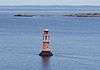 | 1947 | Rödakon shoal about 8 kilometres (5.0 mi) north of Kökar 60°05′07.2″N 20°59′00.7″E / 60.085333°N 20.983528°E | Q (2) WRG 6s. | 12 metres (39 ft) | n/a | C4629 | n/a | named for Nils Gustaf Dalén, a Swedish lighthouse engineer and Nobel Laureate |
| Hamnö Lighthouse | n/a | Hamnö island 59°56′52.4″N 20°52′37.7″E / 59.947889°N 20.877139°E | L Fl W 6s. | 18 metres (59 ft) | n/a | C4728.1 | n/a | ||
| Kalkgrund Range Front Lighthouse |  | n/a | Kalkgrund island 60°03′10.2″N 20°20′05.4″E / 60.052833°N 20.334833°E | Q WRG | 11 metres (36 ft) | n/a | C4566 | n/a | |
| Kalkgrund Range Rear Lighthouse | n/a | Skötskär, southeast of Lumparland 60°03′38.2″N 20°20′33.1″E / 60.060611°N 20.342528°E | L Fl W 6s. | 25 metres (82 ft) | n/a | C4566.1 | n/a | ||
| Kallan Lighthouse | n/a | 5 kilometres (3.1 mi) north of Lökö island 60°26′58.6″N 19°44′22.0″E / 60.449611°N 19.739444°E | Fl WRG 3s. | 8 metres (26 ft) | 16808 | C4465.4 | 4 | ||
| Kökarsören Lighthouse | 1983 | 10 kilometres (6.2 mi) southeast of Kökar 59°46′03.4″N 21°01′05.9″E / 59.767611°N 21.018306°E | Fl W 5s. | 24 metres (79 ft) | 15804 | C4726 | 9 | ||
| Koklubb Lighthouse | n/a | Offshore 5 kilometres (3.1 mi) southeast of Mariehamn harbour 60°00′00.8″N 20°00′03.6″E / 60.000222°N 20.001000°E | V Q (5) 6s. | 6 metres (20 ft) | n/a | C4515 | n/a | ||
| Koxnan Lighthouse | n/a | C. 15 kilometres (9.3 mi) east of Kallan Lighthouse 60°28′02.4″N 19°56′16.6″E / 60.467333°N 19.937944°E | Fl W 5s. | 17 metres (56 ft) | 16812 | C4465 | 6 | ||
| Lågskär Lighthouse | 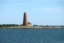 | 1920 | Lågskär island 59°50′28.2″N 19°54′43.9″E / 59.841167°N 19.912194°E | Fl W 12s. | 42 metres (138 ft) | 16096 | C4480 | 11 | |
| Långören Lighthouse | n/a | 8 kilometres (5.0 mi) northwest of Fiskö island 30°22′53.1″N 20°51′36.8″E / 30.381417°N 20.860222°E | Fl WRG 3s. | 10 metres (33 ft) | n/a | C4462.8 | n/a | ||
| Ledskär Lighthouse | 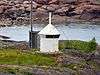 | 1904 est. | Off the southeastern edge of Fasta Åland 59°57′48.8″N 20°10′11.9″E / 59.963556°N 20.169972°E | Q (2) WRG 5s. | 9 metres (30 ft) | 16144 | C4542 | 8 | |
| Lotsberget range Lights | n/a | Mariehamn 60°05′00.8″N 19°56′01.4″E / 60.083556°N 19.933722°E | Iso W 2s. (front), Iso W 6s. (rear) | 34 metres (112 ft) | n/a | C4500 (front), C4500.1 (rear) | n/a | ||
| Lumparudd Lighthouse | n/a | Mariehamn 60°10′05.3″N 20°13′48.2″E / 60.168139°N 20.230056°E | VQ (2) WRG 6s. | 6 metres (20 ft) | n/a | C4525 | n/a | ||
| Marhällan Lighthouse |  | 1938 | Offshore 6 kilometres (3.7 mi) southwestt of Mariehamn 60°01′51.3″N 19°52′18.3″E / 60.030917°N 19.871750°E | Q (3) WRG 6s. | 15 metres (49 ft) | 16760 | C4490 | white: 10 red: 2 green: 2 | |
| Mariehamn Lighthouse | 1898 | Mariehamn 60°06′17.2″N 16°56′41.4″E / 60.104778°N 16.944833°E | Q (2) W 6s. | 8 metres (26 ft) | n/a | C4505.3 | n/a | ||
| Mellanklubb Lighthouse | n/a | Mellanklubb island 60°14′44.0″N 20°33′09.1″E / 60.245556°N 20.552528°E | Fl WRG 3s. | 6 metres (20 ft) | n/a | C4638 | n/a | ||
| Märket Lighthouse | 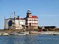 | 1885 | Märket 60°18′3.63″N 19°7′53.15″E / 60.3010083°N 19.1314306°E | Fl W 5s. | 17 metres (56 ft) | 16792 | C4472 | 9 | According to the Finnish Lighthouse Association, the lighthouse at Märket is the most unique lighthouse in all of Finland.[3] |
| Nottö Lighthouse |  | n/a | Notö island 60°18′19.0″N 21°00′37.1″E / 60.305278°N 21.010306°E | Fl WRG 3s. | 7 metres (23 ft) | n/a | C4647 | n/a | |
| Rannö Lighthouse | 1962 | Rannö island 60°31′43.6″N 20°11′55.2″E / 60.528778°N 20.198667°E | Q (2) W 5s. | 20 metres (66 ft) | 16814 | C4464.4 | 5 | ||
| Rågrund Lighthouse | 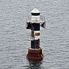 | n/a | Offshore southeast of Fasta Åland 59°57′53.0″N 20°11′29.6″E / 59.964722°N 20.191556°E | Iso WRG 2s. | 10 metres (33 ft) | n/a | C4547 | n/a | |
| Sälskär Lighthouse |  | 1868 | Sälskär island 60°24′42.2″N 19°35′33.2″E / 60.411722°N 19.592556°E | Fl (2) W 12s. | 44 metres (144 ft) | 16800 | C4466 | 12 | |
| Sälsö Lighthouse | n/a | Sälsö island 60°04′31.2″N 20°44′57.3″E / 60.075333°N 20.749250°E | Iso WRG 6s. | 29 metres (95 ft) | n/a | C4615.1 | n/a | ||
| Sånökubb Lighthouse | n/a | Hamnö island, Sottunga municipality 60°05′55.9″N 20°40′41.0″E / 60.098861°N 20.678056°E | Q (2) WRG 6s. | 6 metres (20 ft) | n/a | C4609 | n/a | ||
| Skiftet (Kihti) Lighthouse |  | 1938 | Offshore c. 16 kilometres (9.9 mi) east of Husö island 60°04′33.7″N 21°08′15.3″E / 60.076028°N 21.137583°E | Q (3) WRG 10s. | 11 metres (36 ft) | 16480 | C4630 | 9 | |
| Solovjeva Lighthouse | 1980s | Central Åland Sea 60°11′12.0″N 19°10′18.0″E / 60.186667°N 19.171667°E | VQ (4) W 8s. | 14 metres (46 ft) | 16774 | C4473.5 | 6 | ||
| Sottunga Rödgrund Lighthouse | n/a | Northwest off Husö island 60°05′23.6″N 20°45′34.3″E / 60.089889°N 20.759528°E | Fl WRG 3s. | 14 metres (46 ft) | n/a | C4613 | n/a | ||
| Söderkobb Lighthouse | n/a | Offshore 10 kilometres (6.2 mi) east of Kökar 59°56′01.9″N 21°14′007.7″E / 59.933861°N 21.235472°E | Fl W RGY 6s. | 8 metres (26 ft) | n/a | C4625.5 | n/a | ||
| Stegskär Range Front Lighthouse | n/a | Offshore 10 kilometres (6.2 mi) south of Mariehamn 60°00′46.7″N 19°57′44.5″E / 60.012972°N 19.962361°E | Iso W 2s. | 11 metres (36 ft) | n/a | C4513.4 | n/a | ||
| Stegskärsgrund Lighthouse | n/a | Offshore 5 kilometres (3.1 mi) southeast of Mariehamn 60°00′48.3″N 19°57′41.5″E / 60.013417°N 19.961528°E | L Fl W 5s. | 24 metres (79 ft) | n/a | C4512.1 | n/a | ||
| Stora Lökskär Lighthouse | n/a | Stora Lökskär skerry, 16 kilometres (9.9 mi) southeast of Mariehamn 59°59′01.3″N 20°01′37.8″E / 59.983694°N 20.027167°E | n/a | 6 metres (20 ft) | n/a | C4532 | n/a | ||
| Storgrund Lighthouse |  | 1909 est. | Off the southeastern edge of Fasta Åland 59°58′09.1″N 20°11′46.8″E / 59.969194°N 20.196333°E | Fl WRG 5s, | 9 metres (30 ft) | n/a | C4548 | n/a | |
| Tjurgrund Lighthouse | n/a | Tjurgrund island, Sottunga municipality 60°06′33.8″N 20°41′48.2″E / 60.109389°N 20.696722°E | Fl (2) WRG 6s. | 8 metres (26 ft) | n/a | C4608 | n/a | ||
| Torsholmakobben Lighthouse | n/a | Off Torsholma, Brändö municipality 60°19′45.9″N 21°06′11.6″E / 60.329417°N 21.103222°E | Fl WRG 3s. | 8 metres (26 ft) | n/a | C4649.2 | n/a | ||
| Trännskär Lighthouse | 1940 | Trännskär, Sottunga municipality 60°00′57.2″N 20°47′59.7″E / 60.015889°N 20.799917°E | Q WRG | 8 metres (26 ft) | n/a | C4624 | n/a | ||
| Valberg range lights | n/a | West coast of Eckerö island 60°12′35.7″N 19°31′04.4″E / 60.209917°N 19.517889°E | Q W (front), L Fl W 6s. (rear) | 19 metres (62 ft) | n/a | C4473.3 (front), C4473.31 (rear) | n/a | ||
See also
References
- ↑ "Åland Islands". The Lighthouse Directory. University of North Carolina at Chapel Hill. Retrieved 12 September 2016.
- ↑ List of Lights, Pub. 116: Baltic Sea with Kattegat, Belts and Sound and Gulf of Bothnia (PDF). List of Lights. United States National Geospatial-Intelligence Agency. 2017.
- ↑ "Märket – unique border lighthouse". The Finnish lighthouse association. Archived from the original on 18 September 2007. Retrieved 7 September 2016.
External links
| Wikimedia Commons has media related to Lighthouses in Åland. |
- Rowlett, Russ. "The Lighthouse Directory". University of North Carolina at Chapel Hill.
| Types |
| _-_cropped.jpg) | ||||||
|---|---|---|---|---|---|---|---|---|
| Fixtures | ||||||||
| Maintenance | ||||||||
| Locations | ||||||||
| Categories |
| |||||||
| Global organizations | ||||||||
| ||||||||
This article is issued from
Wikipedia.
The text is licensed under Creative Commons - Attribution - Sharealike.
Additional terms may apply for the media files.