Pocomoke, North Carolina
Coordinates: 36°04′50″N 78°32′25″W / 36.08056°N 78.54028°W Pocomoke is an unincorporated community in western Franklin County, North Carolina, United States near the Granville County line. It is located at the intersection of N.C. Highway 96 and Pocomoke Road (SR 1127), southwest of Franklinton, at an elevation of 522 feet (159 m).[1]
References
- ↑ North Carolina Department of Transportation: State Mapping Resources -- Franklin County, Retrieved Jan. 15, 2015.
Municipalities and communities of Franklin County, North Carolina, United States | ||
|---|---|---|
| Towns | 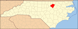 | |
| CDP | ||
| Unincorporated communities | ||
| Footnotes | ‡This populated place also has portions in an adjacent county or counties | |
This article is issued from
Wikipedia.
The text is licensed under Creative Commons - Attribution - Sharealike.
Additional terms may apply for the media files.