Gupton, North Carolina
| Gupton, North Carolina | |
|---|---|
| Unincorporated community | |
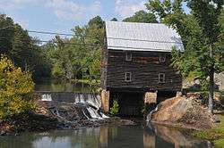 Laurel Mill | |
 Gupton Location of Gupton in North Carolina  Gupton Gupton (the US) | |
| Coordinates: 36°11′49″N 78°09′38″W / 36.19694°N 78.16056°WCoordinates: 36°11′49″N 78°09′38″W / 36.19694°N 78.16056°W | |
| Country | United States |
| State | North Carolina |
| County | Franklin |
| Elevation[1] | 374 ft (114 m) |
| Time zone | UTC-5 (Eastern (EST)) |
| • Summer (DST) | UTC-4 (EDT) |
| Area code(s) | 919 |
| GNIS feature ID | 1006226[1] |
Gupton is an unincorporated community in Franklin County, North Carolina.
Gupton is located about 8 miles East-northeast of Ingleside off North Carolina Highway 561.
Laurel Mill and Col. Jordan Jones House, Dr. Samuel Perry House, and Speed Farm are listed on the National Register of Historic Places.[2]
References
- 1 2 "Gupton". Geographic Names Information System. United States Geological Survey. Retrieved 2008-03-29.
- ↑ National Park Service (2010-07-09). "National Register Information System". National Register of Historic Places. National Park Service.
Municipalities and communities of Franklin County, North Carolina, United States | ||
|---|---|---|
| Towns | 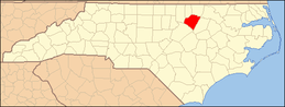 | |
| CDP | ||
| Unincorporated communities | ||
| Footnotes | ‡This populated place also has portions in an adjacent county or counties | |
This article is issued from
Wikipedia.
The text is licensed under Creative Commons - Attribution - Sharealike.
Additional terms may apply for the media files.