Pleasant Valley, Minnesota
| Pleasant Valley, Minnesota | |
|---|---|
| Unincorporated community | |
 Pleasant Valley, Minnesota Location of the community of Pleasant Valley within Wrenshall Township, Carlton County | |
| Coordinates: 46°32′18″N 92°23′06″W / 46.53833°N 92.38500°WCoordinates: 46°32′18″N 92°23′06″W / 46.53833°N 92.38500°W | |
| Country | United States |
| State | Minnesota |
| County | Carlton County |
| Township | Wrenshall Township |
| Elevation | 922 ft (281 m) |
| ZIP code | 55797 |
| Area code(s) | 218 |
| GNIS feature ID | 0649568 |
Pleasant Valley is an unincorporated community in Wrenshall Township, Carlton County, Minnesota, United States.
The community is located between Wrenshall and Holyoke at the junction of Carlton County Roads 1 and 6; and State Highway 23 (MN 23).
Pleasant Valley is located 5 miles south of Wrenshall.
Further reading
- Mn/DOT map of Carlton County – 2012 edition
Municipalities and communities of Carlton County, Minnesota, United States | ||
|---|---|---|
| Cities | 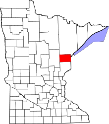 | |
| Townships | ||
| CDPs | ||
| Unorganized territories | ||
| Unincorporated communities | ||
| Indian reservations | ||
| Footnotes | ‡This populated place also has portions in an adjacent county or counties | |
This article is issued from
Wikipedia.
The text is licensed under Creative Commons - Attribution - Sharealike.
Additional terms may apply for the media files.