Corona, Minnesota
| Corona, Minnesota | |
|---|---|
| Unincorporated community | |
 Corona, Minnesota  Corona, Minnesota | |
| Coordinates: 46°40′14″N 92°45′59″W / 46.67056°N 92.76639°WCoordinates: 46°40′14″N 92°45′59″W / 46.67056°N 92.76639°W | |
| Country | United States |
| State | Minnesota |
| County | Carlton |
| Elevation | 1,296 ft (395 m) |
| Time zone | UTC-6 (Central (CST)) |
| • Summer (DST) | UTC-5 (CDT) |
| Area code(s) | 218 |
| GNIS feature ID | 654728[1] |
Corona is an unincorporated community in Carlton County, in the U.S. state of Minnesota.[1] Corona is located at 46°40′14″N 92°45′59″W / 46.67056°N 92.76639°W.
History
A post office was established at Corona in 1910, and remained in operation until it was discontinued in 1921.[2] The name Corona, derived from Latin and meaning "crown", may be allusive of the lofty elevation of the place.[3]
References
- 1 2 U.S. Geological Survey Geographic Names Information System: Corona, Minnesota
- ↑ U.S. Geological Survey Geographic Names Information System: Corona Post Office (historical)
- ↑ Upham, Warren (1920). Minnesota Geographic Names: Their Origin and Historic Significance. Minnesota Historical Society. p. 74.
Municipalities and communities of Carlton County, Minnesota, United States | ||
|---|---|---|
| Cities | 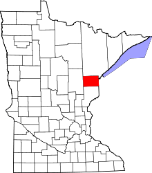 | |
| Townships | ||
| CDPs | ||
| Unorganized territories | ||
| Unincorporated communities | ||
| Indian reservations | ||
| Footnotes | ‡This populated place also has portions in an adjacent county or counties | |
This article is issued from
Wikipedia.
The text is licensed under Creative Commons - Attribution - Sharealike.
Additional terms may apply for the media files.