Holyoke, Minnesota
| Holyoke, Minnesota | |
|---|---|
| Unincorporated community | |
 Holyoke, Minnesota Location of the community of Holyoke within Holyoke Township, Carlton County | |
| Coordinates: 46°28′03″N 92°23′19″W / 46.46750°N 92.38861°WCoordinates: 46°28′03″N 92°23′19″W / 46.46750°N 92.38861°W | |
| Country | United States |
| State | Minnesota |
| County | Carlton County |
| Township | Holyoke Township |
| Elevation | 1,033 ft (315 m) |
| ZIP code | 55749 |
| Area code(s) | 218 |
| GNIS feature ID | 0645142 |
Holyoke is an unincorporated community in Holyoke Township, Carlton County, Minnesota, United States. It is located between Sandstone and Duluth.
Carlton County Road 8 and State Highway 23 (MN 23) are two of the main routes in the community.
Holyoke is located 13 miles south of Wrenshall. The Nemadji State Forest is nearby. The communities of Nickerson, MN and Foxboro, WI are near Holyoke.
Further reading
- Rand McNally Road Atlas – 2007 edition – Minnesota entry
- Official State of Minnesota Highway Map – 2011/2012 edition
- Mn/DOT map of Carlton County – 2012 edition
External links
Municipalities and communities of Carlton County, Minnesota, United States | ||
|---|---|---|
| Cities | 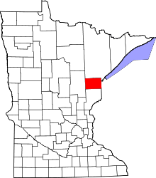 | |
| Townships | ||
| CDPs | ||
| Unorganized territories | ||
| Unincorporated communities | ||
| Indian reservations | ||
| Footnotes | ‡This populated place also has portions in an adjacent county or counties | |
This article is issued from
Wikipedia.
The text is licensed under Creative Commons - Attribution - Sharealike.
Additional terms may apply for the media files.