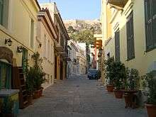
Plaka
| Plaka Πλάκα | |
|---|---|
| Neighborhood | |
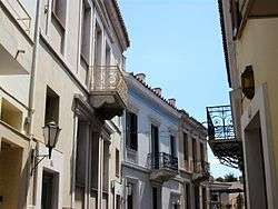 Typical houses of Plaka | |
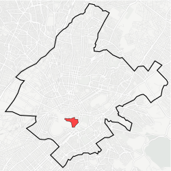 Location within Athens | |
| Coordinates: 37°58′20″N 23°43′50″E / 37.97222°N 23.73056°ECoordinates: 37°58′20″N 23°43′50″E / 37.97222°N 23.73056°E | |
| Country | Greece |
| Region | Attica |
| City | Athens |
| Website | www.cityofathens.gr |
Pláka (Greek: Πλάκα) is the old historical neighborhood of Athens, clustered around the northern and eastern slopes of the Acropolis, and incorporating labyrinthine streets and neoclassical architecture. Plaka is built on top of the residential areas of the ancient town of Athens. It is known as the "Neighborhood of the Gods" due to its proximity to the Acropolis and its many archaeological sites.[1][2]
Name

The toponym "Plaka" was first recorded by a French doctor and archaeologist Jacob Spon in his Spon's Voyage d'Italie, de Dalmatie, de Grèce et du Levant (1678). [3] The name Plaka is of Greek origin, (Ancient Greek: πλάξ, plak-, plax meaning anything flat and broad , Latin: Placus). [4]
Location
Plaka is on the northeast slope of Acropolis, between Syntagma and Monastiraki square. Adrianou Street (running north and south) is the largest and most central street in Plaka and divides it into two areas: the upper level, - Ano Plaka - located right under the Acropolis and the lower level - Kato Plaka - situated between Syntagma and Monastiraki.
History
Plaka was developed mostly around the ruins of Ancient Agora of Athens in an area that has been continuously inhabited since antiquity. During the years of Ottoman rule, Plaka was the known as the "Turkish quarter of Athens",[5] and the seat of the Turkish Voevode (Governor). During the Greek War of Independence, Plaka like the rest of Athens, was temporarily abandoned by its inhabitants because of the severe battles that took place in 1826. The area was repopulated during the first years of King Otto's rule. Plaka had a sizable Arvanite community till the late 19th century, which led some to refer to it as the Arvanite quarter of Athens[6] .[7][8] At the same period the neighborhood of Anafiotika, featuring traditional Cycladic architecture, was built by settlers from the Aegean island of Anafi.[9]
In 1884 a fire burned down a large part of the neighborhood which gave the opportunity for the archaeologists to conduct excavations in the Roman Market and Hadrian’s library. Excavations have been taking place continuously since 19th century.
Modern neighbourhood
Plaka is visited by hundreds of thousands of tourists around the year,[10] and is under strict zoning and conservation regulations, as the only neighborhood in Athens where all utilities (water, power, cable television, telephone, internet, and sewage) lie underground in fully accessible, custom-made tunneling.
Museums in Plaka include the new Acropolis Museum, the new Jewish Museum of Greece, the Museum of Greek Folk Art, an annex of which is the Old Public Baths building, the Frissiras Museum, the Museum of Popular Music Instruments, the Museum of Pavlos and Alexandra Kanellopoulou and the Athens University Museum.
Cinema
Many movies of the Greek cinema were filmed in the area. Some of them include:
Gallery
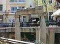 Ancient Roman columns
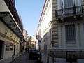 "Karolos Koun" theatre
 Polygnotou street
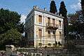
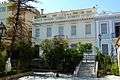 Neoclassical houses
 Detail of a building
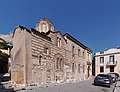 Agios Nikolaos Ragava church
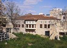 Saint Philothei house
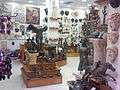 Typical souvenir shop
References
- ↑ City spaces - tourist places: urban tourism precincts By Bruce Hayllar, Tony Griffin, Deborah Edwards page 31 :” Plaka the neighborhood of the Gods...Located at the base of the hill of Acropolis Plaka is the oldest district in Athens.”
- ↑ «Στης Πλάκας τις ανηφοριές...Tα ιδιαίτερα έθιμα, οι γραφικοί τύποι, οι παραδοσιακές ταβέρνες στη γειτονιά του κεφιού και της διασκέδασης» Tου Kώστα Xατζιώτη Ιστορικού, Κυριακή 23 Ιουνίου 1996 Καθημερινή :” Πλάκα η συνοικία των Θεών, όπως την αποκαλούσαν παλαιότερα την γειτονιά που απλώνεται γύρω από τον Ιερό βράχο της Ακρόπολις..”“Plaka, the “neighborhoud of the Gods” as it was called few years ago, the neighborhood that lies around the sacred rock of Acropolis”
- ↑ Voyage d'Italie, de Dalmatie, de Grece, et du Levant: fait aux années 1675. & 1676. Of interest are also the topographic information that Spon recorded. He reports that Athens is divided into eight districts (platomata). These were, Plaka (Albanian plaka (old' women)- plak (old' man) ' (the old' distinti) - Placa (*Ancient Greek plak-, plax 'anything flat and broad , Latin Placus)
- ↑ Athens: a cultural and literary history By Michael Llewellyn Smith page 137 :”The Plaka proper was the small area near the monument of Lysicrates, marked apparently by a stone slab (plaka) at the junction of Tripodon, Adrianou and Kydathinaion streets.”
- ↑ Ancient marbles to American shores: Classical archaeology in the United states. by Stephen L Dyson Chapter 5 The American school of Classical studies at Athens page 181 : “The Plaka, the picturesque Turkish quarter of Athens, had developed over the ruins of ancient Agorra”
- ↑ Jebb, Sir Richard Claverhouse; Todd, Robert B. (2002). Collected Works of Richard Claverhouse Jebb. Continuum International. p. 65. ISBN 1-85506-933-4. Retrieved 2010-06-03.
- ↑ Poulton, Hugh; Taji-Farouki, Suha (1997). Muslim identity and the Balkan State. C Hurst & Co Publishers Ltd. p. 142. ISBN 1-85065-276-7. Retrieved 2010-06-03.
- ↑ Davies, Prebendary (July–December 1880). "Contemporary Books (Classical Literature)". The Contemporary Review. 38: 853. Retrieved 2010-06-03.
- ↑ City spaces - tourist places: urban tourism precincts By Bruce Hayllar, Tony Griffin, Deborah Edwards page 32:” At its highest point, just under the Acropolis, Plaka contains a 19th century recreated island village settlement. The steep, charming, whitewashed structured of the Anafiotika (migrants from the island of Anafi built the small enclave). and intimate tavernas reflect the architecture of the Aegean.”
- ↑ "Plaka Photo Guide".
| Wikimedia Commons has media related to Plaka. |