Athens Towers
| Athens Towers | |
|---|---|
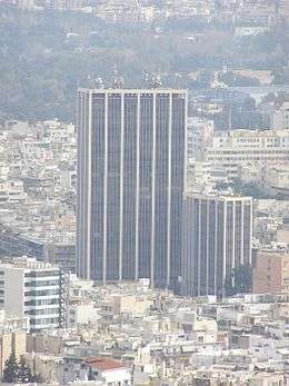 Athens Towers as seen from Lycabettus Hill | |
| General information | |
| Status | Complete |
| Type | Office |
| Location | Athens, Greece |
| Coordinates | 37°59′05″N 23°45′39″E / 37.984587°N 23.760874°E |
| Construction started | 1968 |
| Completed | 1971 |
| Height |
103 m (338 ft) - Athens Tower 1 65 m (213 ft) - Athens Tower 2 |
| Technical details | |
| Floor count |
28 - Athens Tower 1 15 - Athens Tower 2 |
Athens Towers (Greek: Πύργος Αθηνών), is a complex of two buildings situated in Athens, Greece.[1] Athens Tower 1 is 103 m (338 ft)[2] high and is the tallest building in country, while Athens Tower 2 has a height of 65 m (213 ft).[3]
Construction began in 1968 and was completed in 1971. At the time of its completion it was the second tallest building in the Balkans. It is located in the district of Ampelokipi on 2 Messogeion Avenue. It is used by many companies such as Interamerican and Alpha Bank. The architect of Athens Tower is Ioannis Vikelas, who also designed the main building of the Goulandris Museum of Cycladic Art.
Today, the Athens Towers are considered as one of the landmarks of Greece.[4]
History
The Athens Tower was built in a period when the law restricting the maximum height of a building wasn’t active. Up until 1968 the maximum allowed height of a building was 35 meters and from 1985 to now it’s 27 meters. Until 1968, the tallest building in Athens was the 14 storey Athens Hilton, which was completed in 1963. The construction of the Athens Tower lasted from 1968 to 1971 and was built by Αλβέρτης - Δημόπουλος Α.Ε. one of the biggest construction companies of the time. For the construction of the building the 2-4 messogeion site was granted . The building was completed in 1971. During the 1990s telecommunication antennas were added on the roof of the building.
Gallery
 Athens Tower as seen from street level
 The smaller tower (Athens Tower 2)
See also
References
- ↑ Athens Towers - Emporis
- ↑ Athens Tower 1 - Emporis
- ↑ Athens Tower 2 - Emporis
- ↑ "Οι ουρανοξύστες της Αθήνας: Όταν κοιτάς από ψηλά". www.in2life.gr. Retrieved 2018-03-31.
Coordinates: 37°59′05″N 23°45′39″E / 37.984587°N 23.760874°E