Pisco, Peru
| Pisco | ||
|---|---|---|
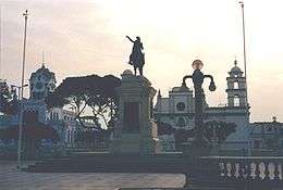  .jpg) .jpg)   Plaza de Armas in 2001. Church was destroyed in the 2007 earthquake | ||
| ||
 Pisco | ||
| Coordinates: 13°42′35.93″S 76°12′11.54″W / 13.7099806°S 76.2032056°WCoordinates: 13°42′35.93″S 76°12′11.54″W / 13.7099806°S 76.2032056°W | ||
| Country |
| |
| Region | Ica | |
| Province | Pisco | |
| District | Pisco | |
| Government | ||
| • Mayor | Jesus Felipe Echegaray Nieto | |
| Area | ||
| • Total | 3,978.19 km2 (1,535.99 sq mi) | |
| Population | ||
| • Estimate (2015)[1] | 104,656 | |
| Demonym(s) | Pisquena(o) | |
| Time zone | UTC-5 (PET) | |

Pisco is a small city located in the Ica Region of Peru, the capital of the Pisco Province. The city is around 9 metres (28 feet) above sea level. Pisco was founded in 1640,[2] close to the indigenous emplacement of the same name. Pisco originally prospered because of its nearby vineyards and became noted for its grape brandy or pisco[3] which was exported from its port. Pisco has an estimated population of 133,926 (est. 2013).[4]
Tourist attractions
Pisco is a Quechua word that means "bird."[3] The area is often visited because of the concentration of marine animals and birds at the Paracas National Reserve, or the Peruvian Galápagos.[5] At the reserve there are the Islas Ballestas, a collection of islands which are off limits to people, but boat tours can get close to. The Chincha Islands are also near its coast. Many bird species can be seen in the islands including pelicans, penguins, cormorants, Peruvian boobies, and Inca terns, as well as sea lions, turtles, dolphins, and whales.
Another attraction in the area is El Candelabro, a giant lamp dug in the rough sand in the method used by the creators of the Nazca Lines.
 El Candelabro, Ballestas Islands
 Pelicans, Ballestas Islands
 Sea Lion, Ballestas Islands
 Local taxi station
 Seals on the Ballestas Islands
In the area where Pisco sits flourished one of the major ancient civilizations in Peru, the Paracas culture. Due to its ease of access, and its crossroads to the Andes the Spaniards may have considered making Pisco the capital, before they decided on Lima.
In the city is the Plaza de Armas, where people buy tejas, small sweets made from pecans and assorted dried fruits. Many different building that surround the Plaza are the statue of José de San Martín, the mansion he lived in, and the Municipal Palace. Other building in the city is the heavily baroque Iglesia de la Compañía, begun in 1689, features a superb carved pulpit and gold-leaf altarpiece.
Near the town, just off the road to Ayacucho, lies the large, well-preserved Inca site of Tambo Colorado.
Climate
The city of Pisco experiences hot arid climate, with warm temperatures and extremely low rainfall prevailing all year-round. According to the Köppen Climate Classification system, Pisco has a mild desert climate, abbreviated BWh on climate maps.[6] The average maximum temperature in the city is 23.7 °C (74.7 °F), ranging from a February peak of 27.7 °C (81.9 °F) to a July low of 20.2 °C (68.4 °F). The average minimum temperature in the city is 15.8 °C (60.4 °F), fluctuating from 19.5 °C (67.1 °F) to 12.9 °C (55.2 °F) in the months of February and August respectively. Rainfall is incredulously low; the average annual rainfall total amounts to a mere 1.5 mm (0.1 in).
| Climate data for Pisco, Peru (1961–1990, extremes 1942–present) | |||||||||||||
|---|---|---|---|---|---|---|---|---|---|---|---|---|---|
| Month | Jan | Feb | Mar | Apr | May | Jun | Jul | Aug | Sep | Oct | Nov | Dec | Year |
| Record high °C (°F) | 33.9 (93) |
33.2 (91.8) |
33.5 (92.3) |
32.0 (89.6) |
30.2 (86.4) |
31.0 (87.8) |
28.0 (82.4) |
28.4 (83.1) |
29.2 (84.6) |
27.0 (80.6) |
28.3 (82.9) |
31.2 (88.2) |
33.9 (93) |
| Average high °C (°F) | 26.9 (80.4) |
27.7 (81.9) |
27.3 (81.1) |
25.7 (78.3) |
23.1 (73.6) |
21.2 (70.2) |
20.2 (68.4) |
20.4 (68.7) |
21.0 (69.8) |
22.0 (71.6) |
23.2 (73.8) |
25.2 (77.4) |
23.7 (74.7) |
| Average low °C (°F) | 18.7 (65.7) |
19.5 (67.1) |
19.0 (66.2) |
17.4 (63.3) |
15.2 (59.4) |
13.8 (56.8) |
13.1 (55.6) |
12.9 (55.2) |
13.3 (55.9) |
14.2 (57.6) |
15.4 (59.7) |
17.1 (62.8) |
15.8 (60.4) |
| Record low °C (°F) | 10.5 (50.9) |
14.3 (57.7) |
12.0 (53.6) |
10.0 (50) |
7.0 (44.6) |
7.8 (46) |
7.0 (44.6) |
7.2 (45) |
8.0 (46.4) |
7.0 (44.6) |
9.5 (49.1) |
9.2 (48.6) |
7.0 (44.6) |
| Average rainfall mm (inches) | 0.2 (0.008) |
0.1 (0.004) |
0.2 (0.008) |
0.0 (0) |
0.0 (0) |
0.1 (0.004) |
0.1 (0.004) |
0.3 (0.012) |
0.2 (0.008) |
0.2 (0.008) |
0.1 (0.004) |
0.0 (0) |
1.5 (0.059) |
| Average rainy days (≥ 1.0 mm) | 0.1 | 0.1 | 0.0 | 0.0 | 0.0 | 0.0 | 0.1 | 0.0 | 0.1 | 0.2 | 0.0 | 0.0 | 0.5 |
| Average relative humidity (%) | 83 | 81 | 81 | 82 | 83 | 82 | 81 | 83 | 84 | 83 | 82 | 82 | 82 |
| Source #1: NOAA[7] | |||||||||||||
| Source #2: Meteo Climat (record highs and lows),[8] Deutscher Wetterdienst ( precipitation days 1970–1990 and humidity 1954–1969)[9] | |||||||||||||
Transport
Pisco is served by the Capitán FAP Renán Elías Olivera Airport (IATA: PIO, ICAO: SPSO), located in Pisco (PIO).[10] This international airport shares facilities with the Peruvian Air Force and is also designated as a back-up airport to the Jorge Chávez International Airport (IATA: LIM, ICAO: SPIM) in Lima, Peru. On September 4, 2012, President Ollanta Humala was present for the beginning of renovations to the airport,[11] which is expected to be operational by 2015 with the ability to receive an anticipated 400,000 passengers a year in 2017.
2007 earthquake

The city was very near the epicenter of the devastating 8.0-magnitude earthquake which struck south central Peru on Wednesday August 15, 2007. Media officials reported that 80% of the city was destroyed, including the central San Clemente Cathedral of Pisco, located in Plaza de Armas in which mass was taking place at the time of the earthquake.[12] The resulting dead account for a reported 30 percent of the total fatalities caused by the earthquake.[13] Several hundred more were killed throughout the city[14] Several years on the city is still recovering from the damage done during the earthquake.[15]
Notable people
- Raúl Porras Barrenechea, historian, diplomat
- Juan de Dios Guevara, chemist
- Abraham Valdelomar, writer
International relations
Twin towns – Sister cities
Pisco is twinned with:
References
- ↑ Perú: Población estimada al 30 de junio y tasa de crecimiento de las ciudades capitales, por departamento, 2011 y 2015. Perú: Estimaciones y proyecciones de población total por sexo de las principales ciudades, 2012-2015 (Report). Instituto Nacional de Estadística e Informática. March 2012. Retrieved 2015-06-03.
- ↑ Pisco celebrates its 371st anniversary
- 1 2 Pisco (Peru) at Encyclopædia Britannica
- ↑ Peru population estimates at INEI.gob.pe
- ↑ Pisco at Trekker.co.il
- ↑ Climate Summary for Pisco, Peru
- ↑ "Pisco Climate Normals 1961–1990". National Oceanic and Atmospheric Administration. Retrieved April 23, 2015.
- ↑ "Station Pisco" (in French). Meteo Climat. Retrieved October 19, 2016.
- ↑ "Klimatafel von Pisco, Prov. Ica / Peru" (PDF). Baseline climate means (1961-1990) from stations all over the world (in German). Deutscher Wetterdienst. Retrieved July 4, 2017.
- ↑ Capitán FAP Renán Elías Olivera Airport
- ↑ Peru starts work at Pisco international airport at Peru this Week
- ↑ Grim quake toll from Peru church at BBC News
- ↑ Alex K Tang, PE and Jorgen Johansson, ed. (2008). Pisco, Peru Earthquake of August 15, 2007. Reston, VA: ASCE, Technical Council on Lifeline Earthquake Engineering. ISBN 9780784410615. Archived from the original on November 14, 2012.
- ↑ New York Times article on the 2007 earthquake
- ↑ Pisco Sin Fronteras, an NGO working to help rebuild Pisco
- ↑ "Town Twinning Agreements". Municipalidad de Rosario - Buenos Aires 711. Retrieved 2014-10-14.
External links
| Wikimedia Commons has media related to Pisco, Peru. |