Chincha Islands
| Islas Chincha (Spanish) | |
|---|---|
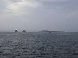 Partial view of the islands. | |
 Chincha Islands | |
| Geography | |
| Location | Pacific Ocean |
| Coordinates | 13°38′24″S 76°24′0″W / 13.64000°S 76.40000°WCoordinates: 13°38′24″S 76°24′0″W / 13.64000°S 76.40000°W |
| Major islands | Chincha Norte, Chincha Centro, Chincha Sur |
| Administration | |
| Region | Ica |
| Additional information | |
| Time zone | |
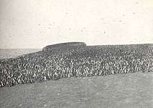
The Chincha Islands (Spanish Islas Chincha) are a group of three small islands 21 kilometres (13 mi) off the southwest coast of Peru, to which they belong, near the town of Pisco. Since pre-Incan times they were of interest for their extensive guano deposits, but the supplies were mostly exhausted by 1874.
Geography
The largest of the islands, Isla Chincha Norte, is 0.8 miles (1.3 km) long and up to 0.6 miles (1.0 km) wide, and rises to a height of 34 metres (112 ft). Isla Chincha Centro is almost the same size as its neighbour to the north, while Isla Chincha Sur is half the size of its neighbours. The islands are mostly granite, and bordered with cliffs on all sides, upon which great numbers of seabirds nest.[1]
History
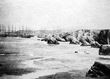
The islands were once the residence of the Chincha people, but only a few remains are to be found today. Peru began the export of guano in 1840. Spain, not having recognized Peru's independence (it was not to do so until 1879) and desiring the guano profits, occupied the islands in April 1864, setting off the Chincha Islands War (1864–1866).
References
- ↑

External links
- Islas Chincha (1865 map)
- Islas Chincha (in Spanish)