Pirappancode
| Pirappancode | |
|---|---|
| village | |
 Pirappancode Location in Kerala, India  Pirappancode Pirappancode (India) | |
| Coordinates: 8°39′0″N 76°55′0″E / 8.65000°N 76.91667°ECoordinates: 8°39′0″N 76°55′0″E / 8.65000°N 76.91667°E | |
| Country |
|
| State | Kerala |
| District | Thiruvananthapuram |
| Government | |
| • Body | Gram panchayat |
| Languages | |
| • Official | Malayalam, English |
| Time zone | UTC+5:30 (IST) |
| PIN | 695607 |
| Coastline | 0 kilometres (0 mi) |
Pirappancode is a village in Thiruvananthapuram district, Kerala. It is located at 8°39′0″N 76°55′0″E / 8.65000°N 76.91667°E.[1]
References
External links
District HQ: Thiruvananthapuram | |||||||
| History | 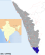 | ||||||
| Geography | |||||||
| Cities and Taluks |
| ||||||
| Transport | |||||||
| Education |
| ||||||
| Buildings | |||||||
| Culture | |||||||
| Lok Sabha constituencies | |||||||
| Sports | |||||||
| Museums | |||||||
This article is issued from
Wikipedia.
The text is licensed under Creative Commons - Attribution - Sharealike.
Additional terms may apply for the media files.