Pinsk Marshes
| Pinsk Marshes Pripet Marshes Пінскія балоты / Прыпяцкія балоты | |
|---|---|
| Natural region | |
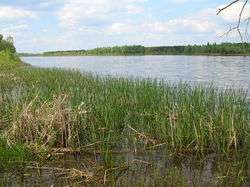 View of the marshy areas bounding the Pripyat River | |
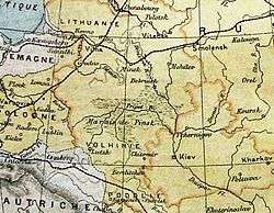 The Pinsk Marshes (Marais de Pinsk) in an 1888 French map by Pierre Foncin | |
| Countries | Belarus and Ukraine |
| Elevation | 135 m (443 ft) |
The Pinsk Marshes (Belarusian: Пінскія балоты, Pinskiya baloty), also known as the Pripet Marshes (Belarusian: Прыпяцкія балоты, Prypiackija baloty), the Polesie Marshes, and the Rokitno Marshes, are a vast natural region of wetlands along the forested basin of the Pripyat River and its tributaries from Brest to the west to Mogilev to the northeast and Kiev to the southeast. It is one of the largest wetland areas of Europe. The city of Pinsk is one of the most important in the area.
Overview
The Pinsk Marshes mostly lie within the Polesian Lowland, hence Polesie Marshes (Woodland Marshes), and occupy most of the southern part of Belarus and the north-west of Ukraine. They cover roughly 104,000 square miles (269,400 km2) surrounding the sandy lowlands of the dense network of rivers and rivulets forming on both sides of the Pripyat River, one of the main tributaries of the Dnieper.[1] Dense woods are interspersed with numerous marshes, moors, ponds and streams extending 300 miles (480 km) west to east and 140 miles (225 km) north to south. The marshes undergo substantial changes in size during the year, with melting snows in springtime and autumn rainfall causing extensive flooding as the river overflows. Drainage of the eastern portion began in 1870, and significant areas have been cleared for pasture and farmland.
History
Historically, for most of the year, the marshes were virtually impassable to major military forces, which influenced strategic planning of all military operations in the region. In Volume VII of Wars of Justitian, by the Roman historian Procopius, is a story that the early Slavs hid out from predators in the Pripet Marshes by breathing through reeds.
Like most other wetlands in Europe, the Pinsk Marshes were once seen as an unhealthy area and a focus of sickness. In the late 19th century, drainage of the marshes recovered 1.5 million hectares of wetlands.[2]
At the start of World War I, the marshes separated the Austro-Hungarian Fourth Army from the XII corps; the few roads that traversed the region were narrow and largely unimproved. That left a wide gap, and the Third Army Corps of the Imperial Russian Army poured in before the Austro-Hungarian Second Army's transfer from Serbia was complete. The Russians soon captured the valuable railhead at Lemberg (now Lviv), then in the far east of Austria-Hungary (now part of the western Ukraine), as a result. Throughout the rest of the war, the wetlands remained one of the principal geographic obstacles of the Eastern Front.
The marshes divided the central and southern theatres of operation during World War II, and they served as a hideout for both Soviet and Polish partisans. At one stage during the war, the German administration planned to drain the marshes, 'cleanse' them of their 'degenerate' inhabitants and repopulate the area with German colonists. Konrad Meyer was the leader in command of the 'Pripet plan'. Hitler scuttled the project late in 1941, as he believed that it might entail Dust Bowl conditions.[3]
German racial anthropologist Theodor Poesche had proposed, in the late 19th century, that the Aryan race evolved in the marshes because of the prevalence of albinism.
In 1942, after an uprising, approximately 1,000 Jews escaped from the Łachwa Ghetto, of whom about 600 were able to take refuge in the Pinsk Marshes.
Known as Pripjet-Sümpfe by the Germans, the wetlands were dreaded by the Wehrmacht troops. During the German invasion of the Soviet Union, the Third Reich armies skirted the wetlands, passing through the north or south of it. However, after the debacle of the Eastern Front in 1944, many retreating units such as the 7th, 35th, 134th and 292nd Infantry Divisions had to cut across the marshy areas. They often needed to build tracks with logs over which they could pull light loads in horse-drawn vehicles.[4]
There was a plan to drain the wetlands during 1952, when the area of the marshes was under Soviet administration.[5]
In 1986, the region became world-famous because of the Chernobyl disaster; however, the Pripet Marshes should not be confused with the ghost city of Pripyat. That ill-fated community within the Chernobyl Exclusion Zone is located 356 km (221 mi) east-southeast of the geographic center of the Pinsk Marshes area.
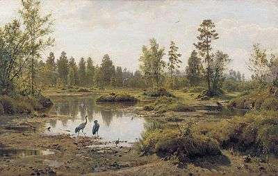 The marshes in a 19th-century painting. |
Wounded German soldiers being evacuated on a light plane in the southern zone of the Pripet Marshes. 1944 |
References
- ↑ Pripet Marshes - Encyclopædia Britannica
- ↑ Wetlands Under Threat. World Wide Fund For Nature Living Waters Campaign. Issues Brief 1, p. 1
- ↑ Blackbourn, David, (2006). The Conquest of Nature: Water, Landscape and the Making of Modern Germany. Jonathan Cape.
- ↑ Pictorial History Of The Second World War; Volume III - Fighting on the Pripet Marshes
- ↑ Karakov, G. (George), 1952 plan for the draining of the Pripet Marshes. New York, N.Y. : Research Program on the U.S.S.R., 1953 (OCoLC)623960881.
External links
Coordinates: 51°48′55″N 24°57′10″E / 51.81528°N 24.95278°E