Pinnacle Hill
| Pinnacle Hill | |
|---|---|
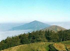 View from Pinnacle Hill | |
| Highest point | |
| Elevation | 358 m (1,175 ft) |
| Coordinates | 52°04′36″N 2°20′24″W / 52.0766°N 2.3400°WCoordinates: 52°04′36″N 2°20′24″W / 52.0766°N 2.3400°W |
| Geography | |
| Location | Malvern Hills, England |
| Topo map | OS Landranger 150 |
| Geology | |
| Age of rock | Pre-Cambrian |
| Mountain type | Igneous, Metamorphic |
| Climbing | |
| Easiest route | Hiking |
Pinnacle Hill is situated in the range of Malvern Hills that runs about 13 kilometres (8 mi) north-south along the Herefordshire-Worcestershire border. It lies between Jubilee Hill and Black Hill and has an elevation of 357 metres (1,171 ft). [1] It is the site of two possible Bronze age round barrows.[2]
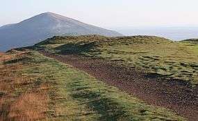
Tumuli on Pinnacle Hill
References
- ↑ "Identification of key views to and from the Malvern Hills:Area of Outstanding Natural Beauty A Report prepared by Cooper Partnership" (PDF). www.malvernhillsaonb.org.uk. The Malvern Hills AONB Partnership. March 2009. p. Appendix Table L2: Assessment of Views from and within Malvern Hills AONB. Retrieved 10 August 2015.
- ↑ "MONUMENT NO. 113797". English Heritage. Retrieved 5 March 2012.
Further reading
External links
This article is issued from
Wikipedia.
The text is licensed under Creative Commons - Attribution - Sharealike.
Additional terms may apply for the media files.