Pigeon River, Minnesota
| Pigeon River, Minnesota | |
|---|---|
| Unincorporated community | |
 Pigeon River, Minnesota Location of the community of Pigeon River within Cook County  Pigeon River, Minnesota Pigeon River, Minnesota (the US) | |
| Coordinates: 48°00′37″N 89°42′30″W / 48.01028°N 89.70833°WCoordinates: 48°00′37″N 89°42′30″W / 48.01028°N 89.70833°W | |
| Country | United States |
| State | Minnesota |
| County | Cook |
| Elevation | 942 ft (287 m) |
| Time zone | UTC-6 (Central (CST)) |
| • Summer (DST) | UTC-5 (CDT) |
| Area code(s) | 218 |
| GNIS feature ID | 1802954[1] |
Pigeon River is an unincorporated community in Cook County, Minnesota, United States; located four miles north of the community of Grand Portage.
The community is situated on the banks of the Pigeon River, which serves as part of the Canada–United States border.
Pigeon River is located at the intersection of Cook County Road 89 and Joe's Road. The community is near the tip of Minnesota's Arrowhead Region in the extreme northeast part of the state. Pigeon River is located within the Grand Portage Indian Reservation.
The Grand Portage National Monument is nearby.
References
- ↑ "US Board on Geographic Names". United States Geological Survey. 2007-10-25. Retrieved 2008-01-31.
Municipalities and communities of Cook County, Minnesota, United States | ||
|---|---|---|
| City | 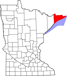 | |
| Townships | ||
| Unorganized territories | ||
| CDP | ||
| Unincorporated communities | ||
| Indian reservation | ||
| Ghost towns | ||
This article is issued from
Wikipedia.
The text is licensed under Creative Commons - Attribution - Sharealike.
Additional terms may apply for the media files.