Lutsen, Minnesota
| Lutsen, Minnesota | |
|---|---|
| Census-designated place (CDP) and Unincorporated community | |
 Lutsen, Minnesota Location of the community of Lutsen within Lutsen Township, Cook County | |
| Coordinates: 47°38′50″N 90°40′29″W / 47.64722°N 90.67472°WCoordinates: 47°38′50″N 90°40′29″W / 47.64722°N 90.67472°W | |
| Country | United States |
| State | Minnesota |
| County | Cook |
| Area[1] | |
| • Total | 10.693 sq mi (27.69 km2) |
| • Land | 10.576 sq mi (27.39 km2) |
| • Water | 0.117 sq mi (0.30 km2) |
| Elevation | 669 ft (204 m) |
| Population (2010)[2] | |
| • Total | 190 |
| • Density | 18/sq mi (6.9/km2) |
| Time zone | UTC-6 (Central (CST)) |
| • Summer (DST) | UTC-5 (CDT) |
| ZIP codes | 55604, 55612 |
| Area code(s) | 218 |
| GNIS feature ID | 657265[3] |
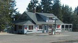
Lockport Marketplace at Lutsen
Lutsen is an unincorporated community and census-designated place (CDP) in Lutsen Township, Cook County, Minnesota, United States. As of the 2010 census, its population was 190.[2]
Lutsen is located within the Superior National Forest, on the North Shore of Lake Superior. It is 18 miles southwest of the city of Grand Marais; and 65 miles northeast of the city of Two Harbors. Cascade River State Park and the Superior Hiking Trail are both nearby.
Minnesota Highway 61 serves as a main route in the community.
Economy
The Lutsen Mountains Ski Resort is the main economic feature of the community; and is known country-wide as being one of the northernmost ski resorts in the 48 contiguous states. The community is also home to at least four resorts.
References
- ↑ "US Gazetteer files: 2010, 2000, and 1990". United States Census Bureau. 2011-02-12. Retrieved 2011-04-23.
- 1 2 "American FactFinder". United States Census Bureau. Retrieved 2011-05-14.
- ↑ "Lutsen". Geographic Names Information System. United States Geological Survey.
Municipalities and communities of Cook County, Minnesota, United States | ||
|---|---|---|
| City | 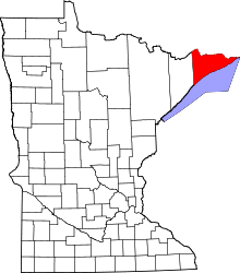 | |
| Townships | ||
| Unorganized territories | ||
| CDP | ||
| Unincorporated communities | ||
| Indian reservation | ||
| Ghost towns | ||
This article is issued from
Wikipedia.
The text is licensed under Creative Commons - Attribution - Sharealike.
Additional terms may apply for the media files.