Piancastagnaio
| Piancastagnaio | ||
|---|---|---|
| Comune | ||
| Comune di Piancastagnaio | ||
 | ||
| ||
 Piancastagnaio Location of Piancastagnaio in Italy | ||
| Coordinates: 42°51′N 11°41′E / 42.850°N 11.683°ECoordinates: 42°51′N 11°41′E / 42.850°N 11.683°E | ||
| Country | Italy | |
| Region | Tuscany | |
| Province | Siena (SI) | |
| Government | ||
| • Mayor | Luigi Vagaggini | |
| Area | ||
| • Total | 69.7 km2 (26.9 sq mi) | |
| Elevation | 772 m (2,533 ft) | |
| Population (28 February 2017)[1] | ||
| • Total | 4,200 | |
| • Density | 60/km2 (160/sq mi) | |
| Demonym(s) | Pianesi | |
| Time zone | UTC+1 (CET) | |
| • Summer (DST) | UTC+2 (CEST) | |
| Postal code | 53025 | |
| Dialing code | 0577 | |
| Website | Official website | |

| Wikimedia Commons has media related to Piancastagnaio. |
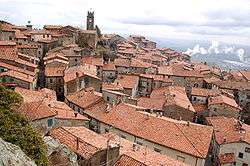
Piancastagnaio is a comune (municipality) in the Province of Siena in the Italian region Tuscany, located about 110 kilometres (68 mi) southeast of Florence and about 60 kilometres (37 mi) southeast of Siena.

The public park and the castle in Piancastagnaio.
It is located on the Monte Amiata slopes.
The main attractions include the Pieve of Santa Maria Assunta, in Baroque style but existing from before 1188, the Palazzo Bourbon Del Monte and the Rocca Aldobrandesca ("Aldobrandeschi Castle").
References
External links

This article is issued from
Wikipedia.
The text is licensed under Creative Commons - Attribution - Sharealike.
Additional terms may apply for the media files.