Pian d'Alma
| Pian d'Alma | |
|---|---|
| Frazione | |
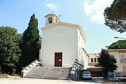 The church of Madonna del Rosario | |
 Pian d'Alma Location of Pian d'Alma in Italy | |
| Coordinates: 42°50′28″N 10°48′59″E / 42.84111°N 10.81639°ECoordinates: 42°50′28″N 10°48′59″E / 42.84111°N 10.81639°E | |
| Country |
|
| Region |
|
| Province | Grosseto (GR) |
| Comune | Castiglione della Pescaia |
| Elevation | 17 m (56 ft) |
| Population (2011) | |
| • Total | 100 |
| Demonym(s) | Piandalmini |
| Time zone | UTC+1 (CET) |
| • Summer (DST) | UTC+2 (CEST) |
| Postal code | 58043 |
| Dialing code | (+39) 0564 |
Pian d'Alma is a village in Tuscany, central Italy, administratively a frazione of the comuni of Castiglione della Pescaia and Scarlino, province of Grosseto. At the time of the 2001 census its population amounted to 24.[1]
Pian d'Alma is about 38 km from Grosseto, 17 km from Castiglione della Pescaia and 14 km from Scarlino, and it is situated in a plain, called padule Pian d'Alma, at the bottom of the hill of Poggio Ballone, near to the Tyrrhenian Sea. The plain is crossed by the Alma river.
Main sights
- Madonna del Rosario, main parish church of the village, it was designed by engineer Ernesto Ganelli in 1958.
- Tower of Alma (10th century), ancient watchtower situated along the village's main street, it is now transformed into a private house.
- Tower of Civette (14th century), old coastal tower, it is located by the sea near to the mouth of Alma river.
- Castle of Maus (11th century), ruins of a fortress situated on the wooded hills which surround the village.
References
Bibliography
- Aldo Mazzolai, Guida della Maremma. Percorsi tra arte e natura, Le Lettere, Florence, 1997
See also
| Wikimedia Commons has media related to Pian d'Alma. |
This article is issued from
Wikipedia.
The text is licensed under Creative Commons - Attribution - Sharealike.
Additional terms may apply for the media files.