Pettigrew, Arkansas
| Pettigrew, Arkansas | |
|---|---|
| Unincorporated community | |
 Pettigrew, Arkansas  Pettigrew, Arkansas | |
| Coordinates: 35°49′04″N 93°38′55″W / 35.81778°N 93.64861°WCoordinates: 35°49′04″N 93°38′55″W / 35.81778°N 93.64861°W | |
| Country | United States |
| State | Arkansas |
| County | Madison |
| Elevation[1] | 1,831 ft (558 m) |
| Time zone | UTC-6 (Central (CST)) |
| • Summer (DST) | UTC-5 (CDT) |
| ZIP code | 72752 |
| Area code(s) | 479 |
| GNIS feature ID | 73058[1] |
Pettigrew is an unincorporated community in Madison County, Arkansas, United States.[1] Pettigrew is located on Arkansas Highway 16, 6.5 miles (10.5 km) east of St. Paul and three miles southwest of Boston. The community is in the Boston Mountains along the banks of the headwaters of the White River.[2] Pettigrew has a post office with ZIP code 72752.[3]
References
- 1 2 3 U.S. Geological Survey Geographic Names Information System: Pettigrew, Arkansas
- ↑ Arkansas Atlas and Gazetteer, DeLorme, 2nd edition 2002, page = 23 ISBN 0-89933-345-1
- ↑ ZIP Code Lookup
Municipalities and communities of Madison County, Arkansas, United States | ||
|---|---|---|
| City | 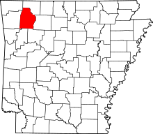 | |
| Towns | ||
| Townships | ||
| Unincorporated communities |
| |
| Ghost towns |
| |
This article is issued from
Wikipedia.
The text is licensed under Creative Commons - Attribution - Sharealike.
Additional terms may apply for the media files.