Brashears, Arkansas
| Brashears, Arkansas | |
|---|---|
| Unincorporated community | |
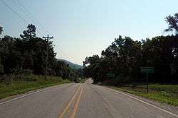 Entrance to Brashears on Highway 16 | |
 Brashears, Arkansas Brashears' position in Arkansas. | |
| Coordinates: 35°48′42″N 93°47′45″W / 35.81167°N 93.79583°WCoordinates: 35°48′42″N 93°47′45″W / 35.81167°N 93.79583°W | |
| Country | United States |
| State | Arkansas |
| County | Madison |
| Elevation | 1,483 ft (452 m) |
| Time zone | UTC-6 (Central (CST)) |
| • Summer (DST) | UTC-5 (CDT) |
| GNIS feature ID | 66390 |
Brashears (also known as Brashears Junction) is an unincorporated community in Madison County, Arkansas, United States.[1] It is located at the junction of AR 16 and AR 23.[2] The community is within the Ozark-St. Francis National Forest and just south of the upper White River. The community of Combs is about two miles west on route 16 and St. Paul is about two miles east.[3]
References
- ↑ U.S. Geological Survey Geographic Names Information System: Brashears, Arkansas
- ↑ "Madison County, Arkansas." Arkansas State Highway and Transportation Department. AHTD Madison County map Retrieved on July 3, 2010.
- ↑ Arkansas Atlas and Gazetteer (Map) (Second ed.). DeLorme. 2002. p. 31. ISBN 0-89933-345-1.
Municipalities and communities of Madison County, Arkansas, United States | ||
|---|---|---|
| City | 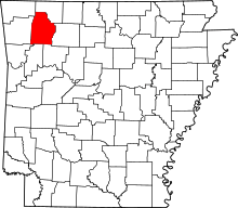 | |
| Towns | ||
| Townships | ||
| Unincorporated communities |
| |
| Ghost towns |
| |
This article is issued from
Wikipedia.
The text is licensed under Creative Commons - Attribution - Sharealike.
Additional terms may apply for the media files.