Yelizovsky District
| Yelizovsky District Елизовский район (Russian) | |
|---|---|
 Location of Yelizovsky District in Kamchatka Krai | |
| Coordinates: 53°12′N 158°24′E / 53.200°N 158.400°ECoordinates: 53°12′N 158°24′E / 53.200°N 158.400°E | |
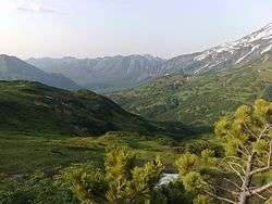 Road to Mutnovsky Glacier in Yelizovsky District | |
 |
.png) |
|
| |
| Location | |
| Country | Russia |
| Federal subject | Kamchatka Krai[1] |
| Administrative structure (as of July 2015) | |
| Administrative center | town of Yelizovo[1] |
| Inhabited localities:[1] | |
| Urban-type settlements[2] | 1 |
| Rural localities | 25 |
| Municipal structure (as of December 2015) | |
| Municipally incorporated as | Yelizovsky Municipal District[3] |
| Municipal divisions:[3] | |
| Urban settlements | 2 |
| Rural settlements | 8 |
| Statistics | |
| Area | 40,996.4 km2 (15,828.8 sq mi)[4] |
| Population (2010 Census) | 24,566 inhabitants[5] |
| • Urban | 6.5% |
| • Rural | 93.5% |
| Density | 0.6/km2 (1.6/sq mi)[6] |
| Time zone | PETT (UTC+12:00)[7] |
| Established | November 17, 1949 |
| Yelizovsky District on WikiCommons | |
| 2010 Census | 24,566[5] |
|---|---|
| 2002 Census | 24,086[8] |
| 1989 Census | 28,720[9] |
| 1979 Census | 19,267[10] |
Yelizovsky District (Russian: Ели́зовский райо́н) is an administrative[1] and municipal[3] district (raion) of Kamchatka Krai, Russia, one of the eleven in the krai. It is located in the south of the krai. The area of the district is 40,996.4 square kilometers (15,828.8 sq mi).[4] Its administrative center is the town of Yelizovo (which is not administratively a part of the district).[1] As of the 2010 Census, the total population of the district was 24,566.[5]
Administrative and municipal status
Within the framework of administrative divisions, Yelizovsky District is one of the eleven in the krai.[1] The town of Yelizovo serves as its administrative center, despite being incorporated separately as a town under krai jurisdiction—an administrative unit with the status equal to that of the districts.[1]
As a municipal division, the district is incorporated as Yelizovsky Municipal District, with Yelizovo Town Under Krai Jurisdiction being incorporated within it as Yelizovskoye Urban Settlement.[3]
References
Notes
- 1 2 3 4 5 6 7 Law #46
- ↑ The count of urban-type settlements may include the work settlements, the resort settlements, the suburban (dacha) settlements, as well as urban-type settlements proper.
- 1 2 3 4 Law #255
- 1 2 Russian Federal Statistics Service. Kamchatka Krai (select Yelizovsky District in the drop-down menus) (in Russian)
- 1 2 3 Russian Federal State Statistics Service (2011). "Всероссийская перепись населения 2010 года. Том 1" [2010 All-Russian Population Census, vol. 1]. Всероссийская перепись населения 2010 года (2010 All-Russia Population Census) (in Russian). Federal State Statistics Service. Retrieved June 29, 2012.
- ↑ The value of density was calculated automatically by dividing the 2010 Census population by the area specified in the infobox. Please note that this value is only approximate as the area specified in the infobox does not necessarily correspond to the area of the entity proper or is reported for the same year as the population.
- ↑ Правительство Российской Федерации. Федеральный закон №107-ФЗ от 3 июня 2011 г. «Об исчислении времени», в ред. Федерального закона №271-ФЗ от 03 июля 2016 г. «О внесении изменений в Федеральный закон "Об исчислении времени"». Вступил в силу по истечении шестидесяти дней после дня официального опубликования (6 августа 2011 г.). Опубликован: "Российская газета", №120, 6 июня 2011 г. (Government of the Russian Federation. Federal Law #107-FZ of June 31, 2011 On Calculating Time, as amended by the Federal Law #271-FZ of July 03, 2016 On Amending Federal Law "On Calculating Time". Effective as of after sixty days following the day of the official publication.).
- ↑ Russian Federal State Statistics Service (May 21, 2004). "Численность населения России, субъектов Российской Федерации в составе федеральных округов, районов, городских поселений, сельских населённых пунктов – районных центров и сельских населённых пунктов с населением 3 тысячи и более человек" [Population of Russia, Its Federal Districts, Federal Subjects, Districts, Urban Localities, Rural Localities—Administrative Centers, and Rural Localities with Population of Over 3,000] (XLS). Всероссийская перепись населения 2002 года [All-Russia Population Census of 2002] (in Russian). Retrieved August 9, 2014.
- ↑ Demoscope Weekly (1989). "Всесоюзная перепись населения 1989 г. Численность наличного населения союзных и автономных республик, автономных областей и округов, краёв, областей, районов, городских поселений и сёл-райцентров" [All Union Population Census of 1989: Present Population of Union and Autonomous Republics, Autonomous Oblasts and Okrugs, Krais, Oblasts, Districts, Urban Settlements, and Villages Serving as District Administrative Centers]. Всесоюзная перепись населения 1989 года [All-Union Population Census of 1989] (in Russian). Институт демографии Национального исследовательского университета: Высшая школа экономики [Institute of Demography at the National Research University: Higher School of Economics]. Retrieved August 9, 2014.
- ↑ "Всесоюзная перепись населения 1979 г. Национальный состав населения по регионам России. (All Union Population Census of 1979. Ethnic composition of the population by regions of Russia.)". Всесоюзная перепись населения 1979 года (All-Union Population Census of 1979) (in Russian). Demoscope Weekly (website of the Institute of Demographics of the State University—Higher School of Economics. 1979. Retrieved 2008-11-25.
Sources
- Законодательное Собрание Камчатского края. Закон №46 от 29 апреля 2008 г. «Об административно-территориальном устройстве Камчатского края», в ред. Закона №659 от 30 июля 2015 г. «О внесении изменения в статью 5 Закона Камчатского края "Об административно-территориальном устройстве Камчатского края"». Вступил в силу со дня официального опубликования. Опубликован: "Официальные Ведомости", №65-69, 6 мая 2008 г. (Legislative Assembly of Kamchatka Krai. Law #46 of April 29, 2008 On the Administrative-Territorial Structure of Kamchatka Krai, as amended by the Law #659 of July 30, 2015 On Amending Article 5 of the Law of Kamchatka Krai "On the Administrative-Territorial Structure of Kamchatka Krai". Effective as of the day of the official publication.).
- Совет народных депутатов Камчатской области. Закон №255 от 29 декабря 2004 г. «Об установлении границ муниципальных образований, расположенных на територии Елизовского района Камчатской области, и о наделении их статусом муниципального района, городского, сельского поселения», в ред. Закона №712 от 7 декабря 2015 г. «О внесении изменений в Закон Камчатской области "Об установлении границ муниципальных образований, расположенных на територии Елизовского района Камчатской области, и о наделении их статусом муниципального района, городского, сельского поселения"». Вступил в силу со дня официального опубликования. Опубликован: "Официальные Ведомости", №3–4, 20 января 2005 г. (Council of People's Deputies of Kamchatka Oblast. Law #255 of December 29, 2004 On Establishing the Borders of the Municipal Formations Located on the Territory of Yelizovsky District of Kamchatka Oblast and on Grantig Them the Status of a Municipal District, Urban, Rural Settlement, as amended by the Law #712 of December 7, 2015 On Amending the Law of Kamchatka Oblast "On Establishing the Borders of the Municipal Formations Located on the Territory of Yelizovsky District of Kamchatka Oblast and on Grantig Them the Status of a Municipal District, Urban, Rural Settlement". Effective as of the day of the official publication.).