Province of Pesaro and Urbino
| Province of Pesaro e Urbino | |
|---|---|
| Province | |
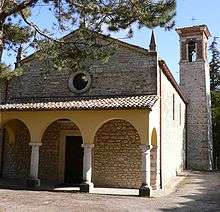
 Rocca of Mondavio | |
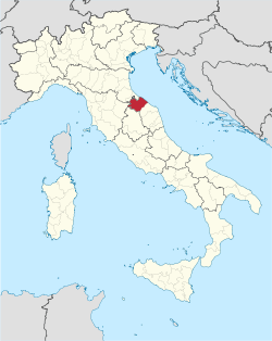 Map highlighting the location of the province of Pesaro e Urbino in Italy | |
| Country |
|
| Region | Marche |
| Capital(s) | Pesaro |
| Comuni | 60 |
| Government | |
| • President | Daniele Tagliolini (PD) |
| Area | |
| • Total | 2,567.78 km2 (991.43 sq mi) |
| Population (31 August 2017) | |
| • Total | 360,187 |
| • Density | 140/km2 (360/sq mi) |
| Time zone | UTC+1 (CET) |
| • Summer (DST) | UTC+2 (CEST) |
| Telephone prefix |
0721 Pesaro 0722 Urbino |
| Vehicle registration | PU |
| ISTAT | 041 |
| Website |
www |
The Province of Pesaro and Urbino (Italian: Provincia di Pesaro e Urbino, pronounced [proˈvintʃa di ˈpeːzaro e urˈbiːno]) is a province in the Marche region of Italy. Its capital is the city of Pesaro. It also borders the state of San Marino. The province is surrounded by San Marino and Emilia Romagna in the north, Umbria and Tuscany in the west, Ancona in the south and the Adriatic Sea on the east.[1] The province has an enclave of the Umbrian commune of Citta' di Castello named Monte Ruperto. The province is also known as "Riviera of Hills". It is mostly covered by hills and is popular for its beaches.
The ceramics museum and the Biblioteca Oliveriana are located in the capital city.[2]
The County Council is based in Pesaro while the headquarters of the provincial administration are in Urbino.
The coat of arms of the province consists of a shield divided into two parts, each part is given the coat of arms of the two capitals.
It has a robust economy with low unemployment, based on craft and small and medium industries, agriculture, tourism, resorts and cultural center. It has a very low per capita energy consumption. The art and craft industry contributes to 22% of the province's GDP.[3] Tourism in the province plays a primary role in the local economy; the main attractions are the sea and the Apennines. The beaches of Gabicce Mare, Pesaro, Fano and Marotta are the most famous ones.[4]
Just outside Pesaro, in the little hamlet of Santa Venerada, close by the chapel Chiostro di Santo Gaetano[5] is the Lucus Pisaurensis, the Sacred Grove of Pisaurum, ancient Pesaro.
History
Earliest sources of reference indicate a pre-Estruscan settlement in Pesaro. The city was founded as Pisaurum[6] by the Romans in 184 BC as a colony of the Picentes, an early Italic people who lived on the northeast coast of Italy during the Iron Age.[7] However, in 1737, 13 ancient votive stones were unearthed in a local Pesaro farm field, each bearing the inscription of a semone[8] or Roman god; these were written in a pre-Estrucan script, indicating a much earlier occupation of the area[9] than the 184 BC Picentes colony.
After the fall of Western Roman Empire, it was included in the Exarchate of Ravenna. In late mediaval times and early Renaissance it was the core of the county of Urbino, and later, the Duchy of Montefeltro. Later it was part of the Papal States and, from the late 19th century, of Kingdom of Italy.
After the referendum of 2006, seven municipalities of Montefeltro were detached from the Province to join the Province of Rimini (Emilia-Romagna) on 15 August 2009.[10][11] The municipalities are Casteldelci, Maiolo, Novafeltria, Pennabilli, San Leo, Sant'Agata Feltria and Talamello.
Geography
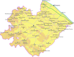
There are 59 comunes (Italian: comuni) in the province.[1]
As of May 31, 2005, the main comuni by population are:
| Commune | Population |
|---|---|
| Pesaro | 94,875 |
| Fano | 61,003 |
| Vallefoglia | 15,029 |
| Urbino | 14,687 |
| Mondolfo | 14,268 |
References
- 1 2 Roy Palmer Domenico (2002). The Regions of Italy: A Reference Guide to History and Culture. Greenwood Publishing Group. p. 217. ISBN 978-0-313-30733-1.
- ↑ "Pesaro and Urbino". Italia. Retrieved 19 September 2014.
- ↑ "Economy and Statistics" (PDF). Circumlavorando (in Italian). Retrieved 19 September 2014.
- ↑ "Pesaro e Ancona le sole province marchigiane al 100% balneabili" [Pesaro and Ancona province of the Marche sun bathing at 100%]. Il Resto del Carlino (in Italian). 24 June 2010. Retrieved 19 September 2014.
- ↑ St. Gaetano Chapel http://www.ilpignocco.it/en/about-us/history/
- ↑ etymology - pi (π), plural, and aurum, reflecting gold, http://www.italythisway.com/places/articles/pesaro-history.php
- ↑ Giacomo Devoto, Gli antichi Italici, Firenze, Vallecchi, 1931
- ↑ An Intermediate Greek-Roman Lexicon, semone http://www.perseus.tufts.edu/hopper/text?doc=Perseus:text:1999.04.0058:entry=dai/mwn
- ↑ History of Pesaro, http://www.italythisway.com/places/articles/pesaro-history.php
- ↑ (in Italian) Article about the legislation Archived 2011-07-22 at the Wayback Machine.
- ↑ (in Italian) Article on "il Resto del Carlino"
External links
| Wikimedia Commons has media related to Province of Pesaro and Urbino. |
- History of Pesaro, Italy

| Provinces and places |  | |
|---|---|---|
| History |
| |
| Politics | ||
| Education and Culture | ||
Categories | ||

Coordinates: 43°54′36.54″N 12°54′47.88″E / 43.9101500°N 12.9133000°E