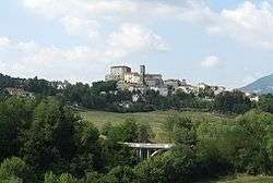
Monte Cerignone
| Monte Cerignone | ||
|---|---|---|
| Comune | ||
| Comune di Monte Cerignone | ||
 | ||
| ||
 Monte Cerignone Location of Monte Cerignone in Italy | ||
| Coordinates: 43°50′N 12°25′E / 43.833°N 12.417°E | ||
| Country | Italy | |
| Region | Marche | |
| Province | Pesaro e Urbino (PU) | |
| Frazioni | Valle di Teva | |
| Government | ||
| • Mayor | Carlo Chiarabini | |
| Area | ||
| • Total | 18.1 km2 (7.0 sq mi) | |
| Elevation | 528 m (1,732 ft) | |
| Population (30 November 2015)[1] | ||
| • Total | 674 | |
| • Density | 37/km2 (96/sq mi) | |
| Demonym(s) | Cerignonesi | |
| Time zone | UTC+1 (CET) | |
| • Summer (DST) | UTC+2 (CEST) | |
| Postal code | 61010 | |
| Dialing code | 0541 | |
| Patron saint | St. Blaise | |
| Saint day | February 3 | |
| Website | Official website | |
Monte Cerignone is a comune (municipality) in the Province of Pesaro e Urbino in the Italian region Marche, located about 90 kilometres (56 mi) northwest of Ancona and about 40 kilometres (25 mi) west of Pesaro.
Monte Cerignone borders the following municipalities: Macerata Feltria, Mercatino Conca, Montecopiolo, Monte Grimano, Sassocorvaro, Tavoleto.
Sights include the Malatesta fortress, which was partly designed by Francesco di Giorgio Martini.
The town has the head office of the coffeeshop chain Caffè Pascucci.[2]
Twin towns

References
- ↑ All demographics and other statistics: Italian statistical institute Istat.
- ↑ "Contatti ed info." Caffè Pascucci. Retrieved on October 19, 2016. "Contatti ed info Pascucci Torrefazione S.p.a. Via Circonvallazione 16/A Montecerignone (PU)"

This article is issued from
Wikipedia.
The text is licensed under Creative Commons - Attribution - Sharealike.
Additional terms may apply for the media files.