San Leo
| San Leo | |
|---|---|
| Comune | |
| Comune di San Leo | |
 | |
 San Leo Location of San Leo in Italy | |
| Coordinates: 43°53′47″N 12°20′36″E / 43.89639°N 12.34333°ECoordinates: 43°53′47″N 12°20′36″E / 43.89639°N 12.34333°E | |
| Country | Italy |
| Region | Emilia-Romagna |
| Province | Rimini (RN) |
| Frazioni | Agenzia, Capicchio, Castelnuovo, Montefotogno, Montemaggio, Pietracuta, Pietramaura, Santa Lucia, Tausano, Torello |
| Government | |
| • Mayor | Mauro Guerra |
| Area | |
| • Total | 53.3 km2 (20.6 sq mi) |
| Elevation | 589 m (1,932 ft) |
| Population (31 December 2014)[1] | |
| • Total | 2,972 |
| • Density | 56/km2 (140/sq mi) |
| Demonym(s) | Leontini |
| Time zone | UTC+1 (CET) |
| • Summer (DST) | UTC+2 (CEST) |
| Postal code | 47865 |
| Dialing code | 0541 |
| Patron saint | Saint Leo |
| Saint day | August 1 |
| Website | Official website |
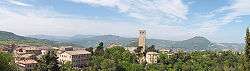
San Leo (Romagnol: San Lé) is a comune (municipality) in the Province of Rimini in the Italian region Emilia-Romagna, located about 135 kilometres (84 mi) southeast of Bologna and about 35 kilometres (22 mi) southwest of Rimini.
Geography
San Leo borders the following municipalities: Acquaviva (San Marino), Chiesanuova (San Marino), Città di San Marino (San Marino), Maiolo, Montecopiolo, Monte Grimano, Novafeltria, Sassofeltrio, Torriana, Verucchio.
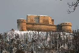
San Leo is home to a large fortress at an elevation of 600 metres (2,000 ft) above sea level. The San Leo Cathedral is a Romanesque architecture church in town.
History
After the referendum of 17 and 18 December 2006, San Leo was detached from the Province of Pesaro and Urbino (Marche) to join Emilia-Romagna and the Province of Rimini on 15 August 2009.[2][3]
Twin towns
References
- ↑ All demographics and other statistics: Italian statistical institute Istat.
- ↑ (in Italian) Article about the legislation Archived 2011-07-22 at the Wayback Machine.
- ↑ (in Italian) Article on "il Resto del Carlino"
External links
| Wikimedia Commons has media related to San Leo (Italy). |
- Official website
- Photos
- The town (Il borgo)
- The fortress
- Photo gallery made by a UNESCO photographer
