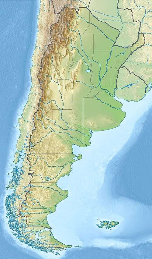
Perito Moreno Glacier
| Perito Moreno Glacier | |
|---|---|
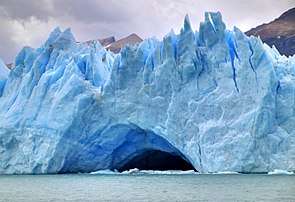
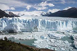 The terminus of the glacier in Lago Argentino | |
 | |
| Coordinates | 50°30′S 73°08′W / 50.500°S 73.133°WCoordinates: 50°30′S 73°08′W / 50.500°S 73.133°W |
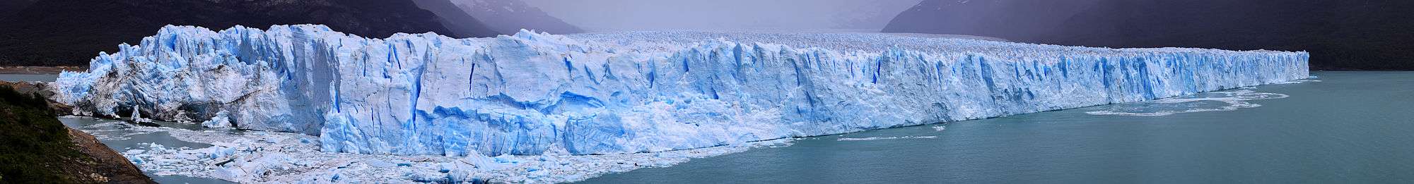
| Area | 250 km2 (97 sq mi) |
| Length | 30 km (19 mi) |
| Width | 5 km (3 mi) |
| Thickness | 170 m (560 ft) |
| Terminus | Lago Argentino |
| Status | Advancing |
The Perito Moreno Glacier (Spanish: Glaciar Perito Moreno) is a glacier located in the Los Glaciares National Park in southwest Santa Cruz Province, Argentina. It is one of the most important tourist attractions in the Argentinian Patagonia.
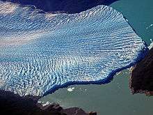
The 250 km2 (97 sq mi) ice formation, and 30 km (19 mi) in length, is one of 48 glaciers fed by the Southern Patagonian Ice Field located in the Andes system shared with Chile. This ice field is the world's third largest reserve of fresh water.
The Perito Moreno Glacier, located 78 kilometres (48 mi) from El Calafate, was named after the explorer Francisco Moreno, a pioneer who studied the region in the 19th century and played a major role in defending the territory of Argentina in the conflict surrounding the international border dispute with Chile.
Status
The glacier is unusual in that it is advancing, while most glaciers worldwide are retreating. The reason remains debated by glaciologists.[1][2] The terminus of the Perito Moreno Glacier is 5 km (3.1 mi) wide, with an average height of 74 m (240 ft) above the surface of the water of Argentino Lake, in Argentina. It has a total ice depth of 170 metres (558 ft).
Rupture
Pressures from the weight of the ice slowly pushes the glacier over the southern arm ("Brazo Rico") of Argentino Lake, damming the section and separating it from the rest of the lake. With no outlet, the water level on the "Brazo Rico" side of the lake can rise by as much as 30 meters above the level of the main body of Argentino Lake. Intermittently, the pressure produced by the height of the dammed water breaks through the ice barrier causing a spectacular rupture, sending a massive outpouring of water from the Brazo Rico section to the main body of Lake Argentino. As the water exits Brazo Rico, the scored shoreline is exposed, showing evidence of the height of the water build-up. This dam–ice-bridge–rupture cycle recurs naturally between once a year to less than once a decade.[3]
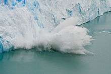
The last rupture occurred on March 10, 2016,[4] and previously, March 4, 2012, 2008, 2006, 2004, 1988, 1986, 1980, 1977, 1975, 1972, 1970, 1966, 1963, 1960, 1956, 1953, 1952, 1947, 1940, 1934 and 1917.[5] It ruptures, on average, about every four to five years.
As of February 2012, before the March 2, 2012 rupture, the glacier dammed the Brazo Rico. The water level there had risen 5.6 meters.
Tourism
Due to its size and accessibility, Perito Moreno is one of the major tourist attractions in southern Patagonia. It is less than two hours by bus from El Calafate, and many tour companies run daily visits. A large visitor centre at the site features a walking circuit which allows visitors to view the southern flank and the east-facing edge of the glacier.
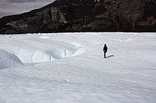
In recent years, trekking tours on the ice have gained popularity. The two standard tours are a "mini-trekking" option, consisting of a short walk of about an hour and a half, and a "big ice" version, which is usually about five hours. Tour companies generally provide crampons to customers.

History
In 1879, the British Captain of the Chilean Navy, Juan Tomás Rogers, sighted for the first time the majestic glacier which he named "Francisco Gormaz", name of the Director of the Hydrographic Office of the Chilean Navy, sponsoring organization of the discovering expedition. Some years later, Rudolph Hauthal, attached to the Argentine Boundary Commission, met the glacier, and decided to name it "Bismarck" in honor of Prussian Chancellor.
In 1881 the Boundary Treaty between Chile and Argentina was signed, which defined the boundaries of both countries in the Andes mountain range up to the 52nd parallel. The glacier is east of the Andes Mountains and empties into Lake Argentino, which also is under Argentine sovereignty. Before the treaty, the area was in dispute between both countries.
Finally, in 1899, after long years of research, compilation of archaeological material, and survey of the area, Argentine Lieutenant Iglesias, who was in charge of the studies for the Argentine Hydrographic Institute, named the coveted glacier Perito Moreno Glacier in homage to Mr. Francisco Pascasio Moreno. [6]
References
- ↑ "Mystery Glaciers Growing as Most Others Retreat". News.nationalgeographic.com. 2009-06-22. Archived from the original on 2017-01-28. Retrieved 2017-03-22.
- ↑ "AAAR - Arctic, Antarctic, and Alpine Research: An Interdisciplinary Journal - Journal Article". Instaar.metapress.com. 2007-05-01. Archived from the original on 2012-06-29. Retrieved 2012-01-19.
- ↑ "Los Glaciares National Park". whc.unesco.org. UNESCO. Retrieved 2017-08-21.
- ↑ "Ice bridge collapses at Perito Moreno Glacier in Argentina; hundreds gather to watch". abc.net.au. Australian Broadcasting Corporation – Online. 2016-03-11. Retrieved 2018-01-31.
- ↑ "El glaciar Perito Moreno se rompe en invierno por primera vez desde 1917" (in Spanish). 2008-10-07. Retrieved 2012-10-10.
- ↑ History of the Perito Moreno Glacier - Argentina Tourism
External links
| Wikimedia Commons has media related to Perito Moreno. |