Penokee, Kansas
| Penokee, Kansas | |
|---|---|
| Unincorporated community | |
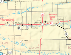 KDOT map of Graham County (legend) | |
 Penokee, Kansas Location within the state of Kansas  Penokee, Kansas Penokee, Kansas (the US) | |
| Coordinates: 39°21′4″N 99°58′19″W / 39.35111°N 99.97194°WCoordinates: 39°21′4″N 99°58′19″W / 39.35111°N 99.97194°W | |
| Country | United States |
| State | Kansas |
| County | Graham |
| Time zone | UTC-6 (Central (CST)) |
| • Summer (DST) | UTC-5 (CDT) |
| GNIS feature ID | 472354[1] |
Penokee (initially Reford) is an unincorporated community in Graham County, Kansas, United States, in the Solomon Valley.[2]
History
Penokee was first named Reford, and under the latter name was platted in 1888 when the railroad was extended to that point.[3] Because the town became mistaken for Rexford, Kansas, the residents renamed their town after the Penokee Mountains near Lake Superior.
References
- ↑ "US Board on Geographic Names". United States Geological Survey. 1978-10-13. Retrieved 2017-12-30.
- ↑ "Penokee, Kansas". Geographic Names Information System. United States Geological Survey.
- ↑ "Origin of Town Names" (PDF). Solomon Valley Highway 24 Heritage Alliance. p. 5. Retrieved 9 April 2018.
Municipalities and communities of Graham County, Kansas, United States | ||
|---|---|---|
| Cities | 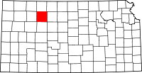 | |
| Unincorporated communities | ||
| Ghost towns | ||
| Townships | ||
This article is issued from
Wikipedia.
The text is licensed under Creative Commons - Attribution - Sharealike.
Additional terms may apply for the media files.