Pencil Bluff, Arkansas
| Pencil Bluff, Arkansas | |
|---|---|
| Unincorporated community | |
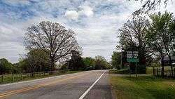 Entering Pencil Bluff from the west | |
 Pencil Bluff, Arkansas  Pencil Bluff, Arkansas | |
| Coordinates: 34°37′47″N 93°44′04″W / 34.62972°N 93.73444°WCoordinates: 34°37′47″N 93°44′04″W / 34.62972°N 93.73444°W | |
| Country | United States |
| State | Arkansas |
| County | Montgomery |
| Elevation | 748 ft (228 m) |
| Time zone | UTC-6 (Central (CST)) |
| • Summer (DST) | UTC-5 (CDT) |
| ZIP code | 71965 |
| Area code(s) | 870 |
| GNIS feature ID | 77974[1] |
Pencil Bluff is an unincorporated community in Montgomery County, Arkansas, United States. Pencil Bluff is located at the junction of U.S. Route 270 and Arkansas Highway 88, 7.5 miles (12.1 km) northwest of Mount Ida. Pencil Bluff has a post office with ZIP code 71965.[2]
References
External links
Municipalities and communities of Montgomery County, Arkansas, United States | ||
|---|---|---|
| City | 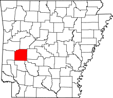 | |
| Towns | ||
| Unincorporated communities | ||
| Footnotes | ‡This populated place also has portions in an adjacent county or counties | |
This article is issued from
Wikipedia.
The text is licensed under Creative Commons - Attribution - Sharealike.
Additional terms may apply for the media files.