Black Springs, Arkansas
| Black Springs, Arkansas | |
|---|---|
| Town | |
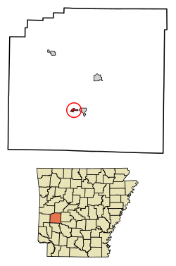 Location of Black Springs in Montgomery County, Arkansas. | |
| Coordinates: 34°27′40″N 93°42′46″W / 34.46111°N 93.71278°WCoordinates: 34°27′40″N 93°42′46″W / 34.46111°N 93.71278°W[1] | |
| Country | United States |
| State | Arkansas |
| County | Montgomery |
| Area[2] | |
| • Total | 0.45 sq mi (1.16 km2) |
| • Land | 0.45 sq mi (1.15 km2) |
| • Water | 0.00 sq mi (0.01 km2) |
| Elevation[1] | 774 ft (236 m) |
| Population (2010) | |
| • Total | 99 |
| • Estimate (2017)[3] | 95 |
| • Density | 213.48/sq mi (82.39/km2) |
| Time zone | UTC-6 (Central (CST)) |
| • Summer (DST) | UTC-5 (CDT) |
| FIPS code | 05-06730 |
Black Springs is a town in Montgomery County, Arkansas, United States. The population was 114 at the 2000 census.
Former U.S. Representative Boyd Anderson Tackett was born in Black Springs. He represented Arkansas's 4th congressional district from 1949 to 1953. He lost the Democratic gubernatorial nomination in 1952 to Francis Cherry.
Geography
Black Springs is located at 34°27′40″N 93°42′46″W / 34.46111°N 93.71278°W (34.4612118, -93.7126919).[1][4]
According to the United States Census Bureau, the town has a total area of 1.1 km² (0.4 mi²), all land.
Demographics
| Historical population | |||
|---|---|---|---|
| Census | Pop. | %± | |
| 1880 | 67 | — | |
| 1940 | 97 | — | |
| 1970 | 72 | — | |
| 1980 | 92 | 27.8% | |
| 1990 | 97 | 5.4% | |
| 2000 | 114 | 17.5% | |
| 2010 | 99 | −13.2% | |
| Est. 2017 | 95 | [3] | −4.0% |
| U.S. Decennial Census[5] 2014 Estimate[6] | |||
As of the census[7] of 2000, there were 114 people, 46 households, and 33 families residing in the town. The population density was 102.4/km² (262.8/mi²). There were 52 housing units at an average density of 46.7/km² (119.9/mi²). The racial makeup of the town was 97.37% White, and 2.63% from two or more races.
There were 46 households out of which 28.3% had children under the age of 18 living with them, 65.2% were married couples living together, 4.3% had a female householder with no husband present, and 26.1% were non-families. 19.6% of all households were made up of individuals and 17.4% had someone living alone who was 65 years of age or older. The average household size was 2.48 and the average family size was 2.82.
In the town, the population was spread out with 25.4% under the age of 18, 2.6% from 18 to 24, 30.7% from 25 to 44, 13.2% from 45 to 64, and 28.1% who were 65 years of age or older. The median age was 40 years. For every 100 females, there were 111.1 males. For every 100 females age 18 and over, there were 107.3 males.
The median income for a household in the town was $27,000, and the median income for a family was $25,250. Males had a median income of $26,875 versus $15,625 for females. The per capita income for the town was $12,312. There were 16.1% of families and 23.7% of the population living below the poverty line, including 34.8% of under eighteens and 10.3% of those over 64.
References
- 1 2 3
- ↑ "2017 U.S. Gazetteer Files". United States Census Bureau. Retrieved Aug 22, 2018.
- 1 2 "Population and Housing Unit Estimates". Retrieved March 24, 2018.
- ↑ "US Gazetteer files: 2010, 2000, and 1990". United States Census Bureau. 2011-02-12. Retrieved 2011-04-23.
- ↑ "Census of Population and Housing". Census.gov. Archived from the original on May 12, 2015. Retrieved June 4, 2015.
- ↑ "Annual Estimates of the Resident Population for Incorporated Places: April 1, 2010 to July 1, 2014". Retrieved June 4, 2015.
- ↑ "American FactFinder". United States Census Bureau. Archived from the original on 2013-09-11. Retrieved 2008-01-31.
External links
Municipalities and communities of Montgomery County, Arkansas, United States | ||
|---|---|---|
| City | 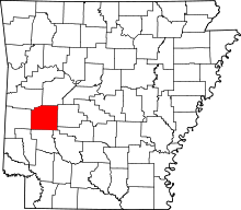 | |
| Towns | ||
| Unincorporated communities | ||
| Footnotes | ‡This populated place also has portions in an adjacent county or counties | |