Peeltree, West Virginia
| Peeltree | |
|---|---|
| Unincorporated community | |
 Peeltree Location within the state of West Virginia  Peeltree Peeltree (the US) | |
| Coordinates: 39°7′46″N 80°12′38″W / 39.12944°N 80.21056°WCoordinates: 39°7′46″N 80°12′38″W / 39.12944°N 80.21056°W | |
| Country | United States |
| State | West Virginia |
| County | Barbour |
| Elevation | 1,079 ft (329 m) |
| Time zone | UTC-5 (Eastern (EST)) |
| • Summer (DST) | UTC-4 (EDT) |
| GNIS ID | 1544690[1] |
Peeltree — formerly Scoop Town, then Peel Tree — is an unincorporated community in Barbour County, West Virginia, United States.
The community takes its name from the nearby Peeltree Run.[2]
References
- ↑ U.S. Geological Survey Geographic Names Information System: Peeltree, West Virginia
- ↑ Kenny, Hamill (1945). West Virginia Place Names: Their Origin and Meaning, Including the Nomenclature of the Streams and Mountains. Piedmont, WV: The Place Name Press. p. 479.
Municipalities and communities of Barbour County, West Virginia, United States | ||
|---|---|---|
| City | 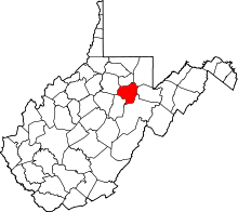 | |
| Magisterial districts |
| |
| Towns | ||
| CDPs | ||
| Unincorporated communities |
| |
This article is issued from
Wikipedia.
The text is licensed under Creative Commons - Attribution - Sharealike.
Additional terms may apply for the media files.