Brownton, West Virginia
| Brownton, West Virginia | |
|---|---|
| Unincorporated community | |
 Brownton, West Virginia  Brownton, West Virginia | |
| Coordinates: 39°13′12″N 80°09′00″W / 39.22000°N 80.15000°WCoordinates: 39°13′12″N 80°09′00″W / 39.22000°N 80.15000°W | |
| Country | United States |
| State | West Virginia |
| County | Barbour |
| Elevation | 1,109 ft (338 m) |
| Time zone | UTC-5 (Eastern (EST)) |
| • Summer (DST) | UTC-4 (EDT) |
| Area code(s) | 304 & 681 |
| GNIS feature ID | 1553996[1] |
Brownton is an unincorporated community and coal town in Barbour County, West Virginia, United States. Brownton is located along County Route 16 3.35 miles (5.39 km) south-southwest of Flemington.[2] Brownton had a post office, which closed on January 24, 2004.[3]
References
- ↑ "Brownton". Geographic Names Information System. United States Geological Survey.
- ↑ Barbour County, West Virginia General Highway Map (PDF) (Map). West Virginia Department of Transportation. 2011. p. 1. Retrieved March 5, 2012.
- ↑ "Postmaster Finder - Post Offices by ZIP Code". United States Postal Service. Retrieved March 5, 2012.
Municipalities and communities of Barbour County, West Virginia, United States | ||
|---|---|---|
| City | 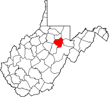 | |
| Magisterial districts |
| |
| Towns | ||
| CDPs | ||
| Unincorporated communities |
| |
This article is issued from
Wikipedia.
The text is licensed under Creative Commons - Attribution - Sharealike.
Additional terms may apply for the media files.