Moatsville, West Virginia
| Moatsville, West Virginia | |
|---|---|
| Unincorporated community | |
 Moatsville, West Virginia  Moatsville, West Virginia | |
| Coordinates: 39°12′37″N 79°55′59″W / 39.21028°N 79.93306°WCoordinates: 39°12′37″N 79°55′59″W / 39.21028°N 79.93306°W | |
| Country | United States |
| State | West Virginia |
| County | Barbour |
| Elevation | 1,234 ft (376 m) |
| Time zone | UTC-5 (Eastern (EST)) |
| • Summer (DST) | UTC-4 (EDT) |
| ZIP code | 26405 |
| Area code(s) | 304 & 681 |
| GNIS feature ID | 1543473[1] |
Moatsville is an unincorporated community in Barbour County, West Virginia, United States. Moatsville is 7 miles (11 km) northeast of Philippi. Moatsville has a post office with ZIP code 26405.[2]
The community most likely was named after the local Moats family.[3]
Moatsville runs along the Tygart River. Most well known for Moats Falls, Moatsville is a nice hang out spot for locals and nearby college students at Alderson Broaddus University. You can find many people enjoying the sun along the river on a summer day. Also along the Arden grate which runs through Moatsville, there are many woods and public hunting grounds for outdoor activities.
References
- ↑ "US Board on Geographic Names". United States Geological Survey. 2007-10-25. Retrieved 2008-01-31.
- ↑ ZIP Code Lookup
- ↑ Kenny, Hamill (1945). West Virginia Place Names: Their Origin and Meaning, Including the Nomenclature of the Streams and Mountains. Piedmont, WV: The Place Name Press. p. 422.
Municipalities and communities of Barbour County, West Virginia, United States | ||
|---|---|---|
| City | 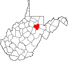 | |
| Magisterial districts |
| |
| Towns | ||
| CDPs | ||
| Unincorporated communities |
| |
This article is issued from
Wikipedia.
The text is licensed under Creative Commons - Attribution - Sharealike.
Additional terms may apply for the media files.