Peach Grove, Kentucky
| Peach Grove, Kentucky | |
|---|---|
| Unincorporated community | |
 Peach Grove, Kentucky | |
| Coordinates: 38°49′51″N 84°17′27″W / 38.83083°N 84.29083°WCoordinates: 38°49′51″N 84°17′27″W / 38.83083°N 84.29083°W | |
| Country | United States |
| State | Kentucky |
| County | Pendleton |
| Elevation | 889 ft (271 m) |
| Time zone | UTC-5 (Eastern (EST)) |
| • Summer (DST) | UTC-4 (EDT) |
| Area code(s) | 859 |
| GNIS feature ID | 508785[1] |
Peach Grove is an unincorporated community in Pendleton County, Kentucky, United States. Peach Grove is located at the junction of Kentucky Route 10 and Kentucky Route 154 in northeastern Pendleton County, 10.3 miles (16.6 km) south-southeast of Alexandria.[2] Immaculate Conception Catholic Church and Cemetery, which is listed on the National Register of Historic Places, is located in Peach Grove.[3]
Notable residents
- Orie Solomon Ware, U.S. Representative from Kentucky[4]
References
- ↑ "Peach Grove". Geographic Names Information System. United States Geological Survey.
- ↑ State Primary Road System: Pendleton County (PDF) (Map). Kentucky Transportation Cabinet. 2011. Retrieved January 4, 2013.
- ↑ National Park Service (2010-07-09). "National Register Information System". National Register of Historic Places. National Park Service.
- ↑ "Ware, Orie Solomon". Biographical Directory of the United States Congress. United States Congress. Retrieved January 4, 2012.
Municipalities and communities of Pendleton County, Kentucky, United States | ||
|---|---|---|
| Cities | 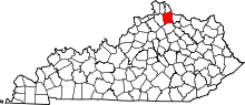 | |
| Unincorporated communities | ||
| Footnotes | ‡This populated place also has portions in an adjacent county or counties | |
This article is issued from
Wikipedia.
The text is licensed under Creative Commons - Attribution - Sharealike.
Additional terms may apply for the media files.