Parnell Township, Sheridan County, Kansas
| Parnell Township | |
|---|---|
| Township | |
 Parnell Township | |
| Coordinates: 39°26′15″N 100°30′32″W / 39.43750°N 100.50889°WCoordinates: 39°26′15″N 100°30′32″W / 39.43750°N 100.50889°W | |
| Country | United States |
| State | Kansas |
| County | Sheridan |
| Area[1] | |
| • Total | 71.33 sq mi (184.7 km2) |
| • Land | 71.30 sq mi (184.7 km2) |
| • Water | 0.03 sq mi (0.08 km2) 0.04% |
| Elevation | 2,812 ft (857 m) |
| Population (2010) | |
| • Total | 102 |
| • Density | 1.4/sq mi (0.55/km2) |
| GNIS feature ID | 471218[2] |
Parnell Township is a township in Sheridan County, Kansas, United States. As of the 2010 Census, it had a population of 102.[3]
References
- ↑ "US Gazetteer files: 2010, 2000, and 1990". United States Census Bureau. 2011-02-12. Retrieved 2011-04-23.
- ↑ "Township of Parnell". Geographic Names Information System. United States Geological Survey.
- ↑ "American FactFinder". United States Census Bureau. Archived from the original on September 11, 2013. Retrieved 2011-05-14.
Municipalities and communities of Sheridan County, Kansas, United States | ||
|---|---|---|
| Cities | 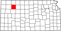 | |
| Unincorporated communities | ||
| Ghost towns | ||
| Townships | ||
This article is issued from
Wikipedia.
The text is licensed under Creative Commons - Attribution - Sharealike.
Additional terms may apply for the media files.