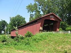
Parker Covered Bridge
|
Parker Covered Bridge | |
 | |
 | |
| Nearest city | Upper Sandusky, Ohio |
|---|---|
| Coordinates | 40°54′11″N 83°14′41″W / 40.90306°N 83.24472°WCoordinates: 40°54′11″N 83°14′41″W / 40.90306°N 83.24472°W |
| Area | less than one acre |
| Built | 1873 |
| Architectural style | Howe Truss |
| NRHP reference # | 75001558[1] |
| Added to NRHP | March 31, 1975 |
The Parker Covered Bridge, near Upper Sandusky, Ohio, was built in 1873 and was listed on the National Register of Historic Places in 1975.[1]
It is located in Crane Township, Wyandot County, Ohio, about 5 miles (8.0 km) northeast of Upper Sandusky on Township Road 40A.
It is a Howe truss covered bridge built by J.C. Davis.[1]
The bridge was burned on May 17, 1991 and was restored in 1993. It is 171.9 feet (52.4 m) in total length with span 162.1 feet (49.4 m) long.[2]
It is covered in the Ohio Historic Places Dictionary.[3]
References
- 1 2 3 National Park Service (2013-11-02). "National Register Information System". National Register of Historic Places. National Park Service.
- ↑ "Parker Covered Bridge 35-88-03". Bridgehunter. With 21 photos.
- ↑ Lorrie K. Owen, ed. (1999). "Ohio Historic Places Dictionary, Volume 2". Somerset Publishers, Inc. p. 1469.
This article is issued from
Wikipedia.
The text is licensed under Creative Commons - Attribution - Sharealike.
Additional terms may apply for the media files.