Parcoal, West Virginia
| Parcoal, West Virginia | |
|---|---|
| Unincorporated community | |
 Parcoal, West Virginia  Parcoal, West Virginia | |
| Coordinates: 38°27′33″N 80°22′24″W / 38.45917°N 80.37333°WCoordinates: 38°27′33″N 80°22′24″W / 38.45917°N 80.37333°W | |
| Country | United States |
| State | West Virginia |
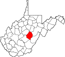
| County | Webster |
| Elevation | 1,562 ft (476 m) |
| Time zone | UTC-5 (Eastern (EST)) |
| • Summer (DST) | UTC-4 (EDT) |
| Area code(s) | 304 & 681 |
| GNIS feature ID | 1555304[1] |
Parcoal is an unincorporated community in Webster County, West Virginia, United States. Parcoal is located along the Elk River 2.3 miles (3.7 km) east-southeast of Webster Springs.[2] Parcoal had a post office, which closed on November 26, 1988.[3]
The community derives its name from the Pardee Curtin Lumber Company, the owner of local coal mines.[4]
References
- ↑ "Parcoal". Geographic Names Information System. United States Geological Survey.
- ↑ Webster County, West Virginia General Highway Map (PDF) (Map). West Virginia Department of Transportation. 2011. p. 2. Archived from the original (PDF) on 2012-04-25. Retrieved January 1, 2012.
- ↑ "Postmaster Finder - Post Offices by ZIP Code". United States Postal Service. Retrieved January 1, 2012.
- ↑ Kenny, Hamill (1945). West Virginia Place Names: Their Origin and Meaning, Including the Nomenclature of the Streams and Mountains. Piedmont, WV: The Place Name Press. p. 473.
This article is issued from
Wikipedia.
The text is licensed under Creative Commons - Attribution - Sharealike.
Additional terms may apply for the media files.