Dyer, West Virginia
| Dyer, West Virginia | |
|---|---|
| Unincorporated community | |
 Methodist church | |
 Dyer, West Virginia  Dyer, West Virginia | |
| Coordinates: 38°22′52″N 80°28′29″W / 38.38111°N 80.47472°WCoordinates: 38°22′52″N 80°28′29″W / 38.38111°N 80.47472°W | |
| Country | United States |
| State | West Virginia |
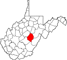
| County | Webster |
| Elevation | 2,221 ft (677 m) |
| Time zone | UTC-5 (Eastern (EST)) |
| • Summer (DST) | UTC-4 (EDT) |
| Area code(s) | 304 & 681 |
| GNIS feature ID | 1554342[1] |
Dyer is an unincorporated community in Webster County, West Virginia, United States. Dyer is located on the Williams River and County Route 46 4.9 miles (7.9 km) east-southeast of Cowen.[2]
G. M. Dyer, an early postmaster, gave the community his name.[3]
References
- ↑ U.S. Geological Survey Geographic Names Information System: Dyer, West Virginia
- ↑ Webster County, West Virginia General Highway Map (PDF) (Map). West Virginia Department of Transportation. 2011. p. 2. Archived from the original (PDF) on 2012-04-25. Retrieved December 12, 2011.
- ↑ Kenny, Hamill (1945). West Virginia Place Names: Their Origin and Meaning, Including the Nomenclature of the Streams and Mountains. Piedmont, WV: The Place Name Press. p. 219.
This article is issued from
Wikipedia.
The text is licensed under Creative Commons - Attribution - Sharealike.
Additional terms may apply for the media files.