Pano Dikomo
| Pano Dikomo | |
|---|---|
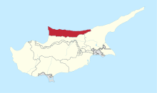
 Pano Dikomo Location in Cyprus | |
| Coordinates: 35°16′41″N 33°19′19″E / 35.27806°N 33.32194°ECoordinates: 35°16′41″N 33°19′19″E / 35.27806°N 33.32194°E | |
| Country |
|
| • District | Kyrenia District |
| Country (controlled by) |
|
| • District | Girne District |
| Time zone | UTC+2 (EET) |
| • Summer (DST) | UTC+3 (EEST) |
| Website | Turkish Cypriot municipality |
Pano Dikomo (Greek: Πάνω Δίκωμο; Turkish: Yukarı Dikmen) is a village in Cyprus, located about halfway between Nicosia and Kyrenia. De facto, it is under the control of Northern Cyprus.[1] According to Northern Cyprus, Pano Dikomo is part of Dikomo.[1]
References
- 1 2 "Pano Dikomo". www.prio-cyprus-displacement.net. Archived from the original on 2018-09-06. Retrieved 2018-09-06.
This article is issued from
Wikipedia.
The text is licensed under Creative Commons - Attribution - Sharealike.
Additional terms may apply for the media files.