Pangburn, Arkansas
| Pangburn, Arkansas | |
|---|---|
| City | |
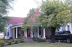 The Avanell Wright House in Pangburn is listed on the National Register of Historic Places | |
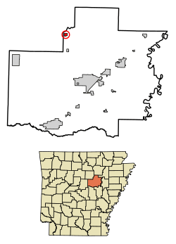 Location of Pangburn in White County, Arkansas. | |
| Coordinates: 35°25′36″N 91°50′13″W / 35.42667°N 91.83694°WCoordinates: 35°25′36″N 91°50′13″W / 35.42667°N 91.83694°W | |
| Country | United States |
| State | Arkansas |
| County | White |
| Area[1] | |
| • Total | 0.55 sq mi (1.41 km2) |
| • Land | 0.55 sq mi (1.41 km2) |
| • Water | 0.00 sq mi (0.00 km2) |
| Elevation | 348 ft (106 m) |
| Population (2010) | |
| • Total | 601 |
| • Estimate (2017)[2] | 585 |
| • Density | 1,073.39/sq mi (414.50/km2) |
| Time zone | UTC-6 (Central (CST)) |
| • Summer (DST) | UTC-5 (CDT) |
| ZIP code | 72121 |
| Area code(s) | 501 |
| FIPS code | 05-53240 |
| GNIS feature ID | 53143[3] |
Pangburn is a city in White County, Arkansas, United States.[3] The population was 601 at the 2010 census.
Geography
According to the United States Census Bureau, the city has a total area of 0.6 square miles (1.6 km2), all land.
Demographics
| Historical population | |||
|---|---|---|---|
| Census | Pop. | %± | |
| 1920 | 706 | — | |
| 1930 | 634 | −10.2% | |
| 1940 | 595 | −6.2% | |
| 1950 | 669 | 12.4% | |
| 1960 | 489 | −26.9% | |
| 1970 | 654 | 33.7% | |
| 1980 | 673 | 2.9% | |
| 1990 | 630 | −6.4% | |
| 2000 | 654 | 3.8% | |
| 2010 | 601 | −8.1% | |
| Est. 2017 | 585 | [2] | −2.7% |
| U.S. Decennial Census[4] | |||
As of the census[5] of 2000, there were 654 people, 275 households, and 188 families residing in the city. The population density was 1,160.1 people per square mile (450.9/km²). There were 332 housing units at an average density of 588.9/sq mi (228.9/km²). The racial makeup of the city was 98.78% White, 0.15% Black or African American, 0.15% Native American, 0.61% from other races, and 0.31% from two or more races. 1.53% of the population were Hispanic or Latino of any race.
There were 275 households out of which 30.5% had children under the age of 18 living with them, 49.1% were married couples living together, 16.0% had a female householder with no husband present, and 31.6% were non-families. 28.4% of all households were made up of individuals and 16.4% had someone living alone who was 65 years of age or older. The average household size was 2.38 and the average family size was 2.88.
In the city, the population was spread out with 28.0% under the age of 18, 8.1% from 18 to 24, 25.1% from 25 to 44, 20.8% from 45 to 64, and 18.0% who were 65 years of age or older. The median age was 36 years. For every 100 females, there were 87.4 males. For every 100 females age 18 and over, there were 84.0 males.
The median income for a household in the city was $25,735, and the median income for a family was $31,250. Males had a median income of $26,750 versus $18,594 for females. The per capita income for the city was $15,234. About 10.1% of families and 15.9% of the population were below the poverty line, including 23.2% of those under age 18 and 16.3% of those age 65 or over.
Education
Public education is provided to elementary and secondary school students by the Pangburn School District, which includes Pangburn High School.
References
- ↑ "2017 U.S. Gazetteer Files". United States Census Bureau. Retrieved Aug 22, 2018.
- 1 2 "Population and Housing Unit Estimates". Retrieved March 24, 2018.
- 1 2 U.S. Geological Survey Geographic Names Information System: Pangburn
- ↑ "Census of Population and Housing". Census.gov. Retrieved June 4, 2015.
- ↑ "American FactFinder". United States Census Bureau. Retrieved 2008-01-31.
Municipalities and communities of White County, Arkansas, United States | ||
|---|---|---|
| Cities | 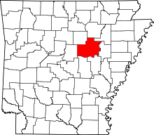 | |
| Towns | ||
| Unincorporated communities |
| |