Kensett, Arkansas
| Kensett, Arkansas | |
|---|---|
| City | |
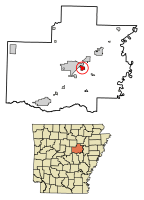 Location of Kensett in White County, Arkansas. | |
| Coordinates: 35°13′58″N 91°40′13″W / 35.23278°N 91.67028°WCoordinates: 35°13′58″N 91°40′13″W / 35.23278°N 91.67028°W | |
| Country | United States |
| State | Arkansas |
| County | White |
| Area[1] | |
| • Total | 1.84 sq mi (4.77 km2) |
| • Land | 1.83 sq mi (4.74 km2) |
| • Water | 0.01 sq mi (0.03 km2) |
| Elevation | 223 ft (68 m) |
| Population (2010) | |
| • Total | 1,648 |
| • Estimate (2017)[2] | 1,633 |
| • Density | 892.35/sq mi (344.54/km2) |
| Time zone | UTC-6 (Central (CST)) |
| • Summer (DST) | UTC-5 (CDT) |
| ZIP code | 72082 |
| Area code(s) | 501 |
| FIPS code | 05-36430 |
| GNIS feature ID | 0081873 |
Kensett is a city in White County, Arkansas, United States. Located adjacent to the east side of Searcy, the city is the hometown of noted legislator Wilbur D. Mills, who was influential throughout the 1960s and 1970s in the United States House of Representatives.
Allen Edge is the current mayor. The population was 1,791 at the 2000 census. Many companies have moved to Kensett to support the natural gas industry. Kensett is a center for landscaping and nursery activity. Double Springs sod farm, Latina Nursery (well known for Japanese maples and peach trees), and Two Rivers Nursery are all located in or near Kensett. There are several restaurants, and Kensett has the lowest sales tax rate in White County.
Kensett was a stop on the defunct Missouri and North Arkansas Railroad, which provided passenger and freight service from Joplin, Missouri, to Helena in Phillips County in eastern Arkansas, from 1906 until its disestablishment in 1946.[3] At Kensett, the M&NA connected with the St. Louis, Iron Mountain and Southern Railway,[4] later the Missouri Pacific Railroad, now the Union Pacific.
Geography
Kensett is located at 35°13′58″N 91°40′13″W / 35.23278°N 91.67028°W (35.232687, -91.670194).[5]
According to the United States Census Bureau, the city has a total area of 1.8 square miles (4.7 km2), of which 1.8 square miles (4.7 km2) is land and 0.56% is water.
Demographics
| Historical population | |||
|---|---|---|---|
| Census | Pop. | %± | |
| 1880 | 86 | — | |
| 1920 | 480 | — | |
| 1930 | 889 | 85.2% | |
| 1940 | 827 | −7.0% | |
| 1950 | 829 | 0.2% | |
| 1960 | 905 | 9.2% | |
| 1970 | 1,444 | 59.6% | |
| 1980 | 1,751 | 21.3% | |
| 1990 | 1,741 | −0.6% | |
| 2000 | 1,791 | 2.9% | |
| 2010 | 1,648 | −8.0% | |
| Est. 2017 | 1,633 | [2] | −0.9% |
| U.S. Decennial Census[6] | |||
As of the census[7] of 2000, there were 1,791 people, 699 households, and 445 families residing in the city. The population density was 1,008.4 people per square mile (388.5/km²). There were 778 housing units at an average density of 438.0/sq mi (168.8/km²). The racial makeup of the city was 70.24% White, 24.29% Black or African American, 0.17% Native American, 0.37% Asian, 2.40% from other races, and 2.57% from two or more races. 4.02% of the population were Hispanic or Latino of any race.
There were 699 households out of which 29.6% had children under the age of 18 living with them, 41.1% were married couples living together, 17.9% had a female householder with no husband present, and 36.2% were non-families. 32.3% of all households were made up of individuals and 14.3% had someone living alone who was 65 years of age or older. The average household size was 2.42 and the average family size was 3.06.
In the city, the population was spread out with 26.0% under the age of 18, 7.9% from 18 to 24, 25.5% from 25 to 44, 20.8% from 45 to 64, and 19.9% who were 65 years of age or older. The median age was 38 years. For every 100 females, there were 80.7 males. For every 100 females age 18 and over, there were 74.5 males.
The median income for a household in the city was $20,478, and the median income for a family was $26,161. Males had a median income of $22,763 versus $17,500 for females. The per capita income for the city was $11,049. About 26.3% of families and 30.6% of the population were below the poverty line, including 48.5% of those under age 18 and 21.4% of those age 65 or over.
Education
Residents are zoned to the Riverview School District, which operates Kensett Elementary School, Riverview Junior High School in Searcy, and Riverview High School in Searcy.
The Riverview district is the result of a consolidation, effective July 1, 1991, of the Judsonia, Kensett, and Griffithville school districts.[8]
References
- ↑ "2017 U.S. Gazetteer Files". United States Census Bureau. Retrieved Aug 22, 2018.
- 1 2 "Population and Housing Unit Estimates". Retrieved March 24, 2018.
- ↑ "H. Glenn Mosenthin, "Missouri and North Arkansas Railroad"". encyclopediaofarkansas.net. Retrieved April 28, 2013.
- ↑ "Map of the St. Louis, Iron Mountain and Southern Railway, and connections". David Rumsey Map Collection. Texas & Pacific Railway Company, 1878. Retrieved 1 May 2018.
- ↑ "US Gazetteer files: 2010, 2000, and 1990". United States Census Bureau. 2011-02-12. Retrieved 2011-04-23.
- ↑ "Census of Population and Housing". Census.gov. Archived from the original on May 12, 2015. Retrieved June 4, 2015.
- ↑ "American FactFinder". United States Census Bureau. Retrieved 2008-01-31.
- ↑ "ConsolidationAnnex_from_1983.xls." Arkansas Department of Education. Retrieved on October 13, 2017.
External links
Municipalities and communities of White County, Arkansas, United States | ||
|---|---|---|
| Cities |  | |
| Towns | ||
| Unincorporated communities |
| |