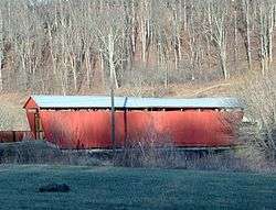
Palos Covered Bridge
|
Palos Covered Bridge | |
 | |
 | |
| Nearest city | Glouster, Ohio |
|---|---|
| Coordinates | 39°31′31″N 82°04′19″W / 39.52528°N 82.07194°WCoordinates: 39°31′31″N 82°04′19″W / 39.52528°N 82.07194°W |
| Area | less than one acre |
| Architectural style | Multiple kingpost truss |
| NRHP reference # | 77001041[1] |
| Added to NRHP | November 11, 1977 |
The Palos Covered Bridge, in Athens County, Ohio near Glouster, was listed on the National Register of Historic Places in 1977. It is a multiple kingpost truss covered bridge.[1]
It is a single-span bridge spanning the east fork of Sunday Creek about one mile north of Glouster off State Route 13, in Trimble Township, Athens County, Ohio. It served the W. P. Rice Mine, a coal mine which operated from 1913 to 1925.[2]
References
- 1 2 National Park Service (2013-11-02). "National Register Information System". National Register of Historic Places. National Park Service.
- ↑ Lorrie K. Owen, ed. (1999). "Ohio Historic Places Dictionary, Volume 2". Somerset Publishers, Inc. p. 46.
| Topics | |
|---|---|
| Lists by states |
|
| Lists by insular areas | |
| Lists by associated states | |
| Other areas | |
| |
Covered bridges in Ohio
This article is issued from
Wikipedia.
The text is licensed under Creative Commons - Attribution - Sharealike.
Additional terms may apply for the media files.