Palo Alto, Mississippi
|
Town of Palo Alto | |
  | |
| Location | Clay County, Mississippi northwest of West Point |
|---|---|
| Coordinates | 33°40′50″N 88°48′0″W / 33.68056°N 88.80000°WCoordinates: 33°40′50″N 88°48′0″W / 33.68056°N 88.80000°W |
| Area | 196.4 acres (79.5 ha) |
| Built | 1846 |
| NRHP reference # | 87000473[1] |
| Added to NRHP | August 20, 1987 |
Palo Alto (also Savannah) is a ghost town in Clay County, Mississippi.[2] Established c. 1846,[1] it is located at 33°40′50″N 88°48′0″W / 33.68056°N 88.80000°W (33.6806738, -88.8000525) at an elevation of 279 feet (85 m).[2]
In 1876, Palo Alto was the site of an incident in which a group of heavily armed white men brought a piece of field artillery and broke up a meeting of the Republican Club in order to suppress black voters.[3]
In 1987, the townsite was listed on the National Register of Historic Places under the name of "Town of Palo Alto." Nearly 200 acres (81 ha) were listed on the Register as part of the community.[1]
References
- 1 2 3 National Park Service (2009-03-13). "National Register Information System". National Register of Historic Places. National Park Service.
- 1 2 U.S. Geological Survey Geographic Names Information System: Palo Alto, Mississippi
- ↑ "Full text of "Mississippi: Testimony as to denial of elective franchise in Mississippi at the elections of 1875 and 1876, taken under the resolution of the Senate of December 5, 1876"". 5 December 1876. Retrieved 17 December 2017.
| Topics | |
|---|---|
| Lists by states |
|
| Lists by insular areas | |
| Lists by associated states | |
| Other areas | |
| |
Municipalities and communities of Clay County, Mississippi, United States | ||
|---|---|---|
| City | 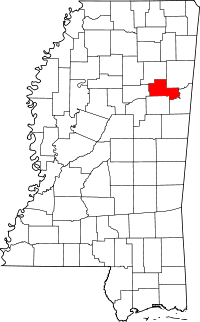 | |
| Unincorporated communities | ||
| Ghost town | ||
This article is issued from
Wikipedia.
The text is licensed under Creative Commons - Attribution - Sharealike.
Additional terms may apply for the media files.