Palaikythro
| Palaikythro | |
|---|---|
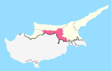
 Palaikythro Location in Cyprus | |
| Coordinates: 35°12′24″N 33°29′36″E / 35.20667°N 33.49333°ECoordinates: 35°12′24″N 33°29′36″E / 35.20667°N 33.49333°E | |
| Country |
|
| • District | Nicosia District |
| Country (controlled by) |
|
| • District | Lefkoşa District |
| Time zone | UTC+2 (EET) |
| • Summer (DST) | UTC+3 (EEST) |
Palaikythro (Greek: Παλαίκυθρο, Turkish: Balıkesir) is a village in the Nicosia District of Cyprus, located 6 km south of Kythrea, on the main Nicosia-Famagusta highway. The village is under de facto control of Northern Cyprus.

This article is issued from
Wikipedia.
The text is licensed under Creative Commons - Attribution - Sharealike.
Additional terms may apply for the media files.