Kato Pyrgos
| Kato Pyrgos | |
|---|---|
| Κάτω Πύργος (Greek) Kato Pirgo (Turkish) | |
 Kato Pyrgos | |
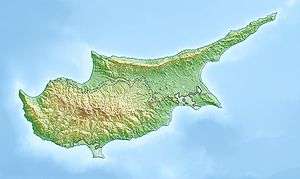 Kato Pyrgos Location in Cyprus | |
| Coordinates: 35°10′52″N 32°41′08″E / 35.18111°N 32.68556°ECoordinates: 35°10′52″N 32°41′08″E / 35.18111°N 32.68556°E | |
| Country |
|
| District | Nicosia District |
| Population (2011)[1] | |
| • Total | 1,036 |
| Time zone | UTC+2 (EET) |
| • Summer (DST) | UTC+3 (EEST) |
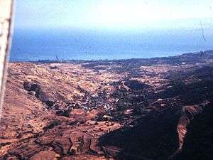
Kato Pyrgos (Greek: Κάτω Πύργος) is a village in Cyprus. Kato Pyrgos is the only Cypriot village located on the Morphou Bay controlled by the Republic of Cyprus. Due to its location, being surrounded by the Troödos Mountains, the Turkish controlled exclave of Kokkina, and the Green Line, it is rather isolated and difficult to reach and gets significant numbers of visitors only in August during summer vacation.
A Green Line crossing point was opened near Kato Pyrgos on 18 October 2010 to facilitate travel from there to Nicosia.
References
External links

This article is issued from
Wikipedia.
The text is licensed under Creative Commons - Attribution - Sharealike.
Additional terms may apply for the media files.