Lakatamia
| Lakatamia | |
|---|---|
 Lakatamia Location in Cyprus | |
| Coordinates: 35°7′0″N 33°19′0″E / 35.11667°N 33.31667°ECoordinates: 35°7′0″N 33°19′0″E / 35.11667°N 33.31667°E | |
| Country |
|
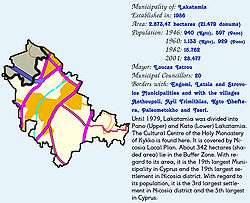
| District | Nicosia District |
| Government | |
| • Type | Municipality |
| • Mayor | Photoula Hadjipapa (AKEL) |
| Population (2011)[1] | |
| • Total | 38,345 |
| Time zone | UTC+2 (EET) |
| • Summer (DST) | UTC+3 (EEST) |
| Website |
www |
Concise presentation of Lakatamia
Lakatamia (Greek: Λακατάμια [lakaˈtamɳa]; Turkish: Lakadamya) is a southwestern suburb of Nicosia, Cyprus. In 2011, it had a population of 38,345.
Due to the expansion of the Nicosia urban area, Lakatamia has grown from two small villages (Upper and Lower Lakatamia) into a sizeable suburb. Lower Lakatamia used to be inhabited by both Greek and Turkish Cypriots until the mid-1950s. Its name originates from "alakatia", i.e. wells which were apparently abundant in the old village. Lakatamia Airfield, an airstrip used by the Cypriot National Guard, is located to the east of Lakatamia.
Sister cities
Lakatamia is twinned with the following cities:

References
- ↑ "C1. POPULATION ENUMERATED BY SEX, AGE, DISTRICT, MUNICIPALITY/COMMUNITY AND QUARTER (1.10.2011)", Population - Place of Residence, 2011, Statistical Service of the Republic of Cyprus, 2014-04-17, archived from the original on 2014-04-20, retrieved 2014-04-20

| Nicosia District | |
|---|---|
| Limassol District | |
| Larnaca District | |
| Famagusta District | |
| Paphos District | |
| Kyrenia District | |
This article is issued from
Wikipedia.
The text is licensed under Creative Commons - Attribution - Sharealike.
Additional terms may apply for the media files.