Pajarito Mesa, New Mexico
| Pajarito Mesa, New Mexico | |
|---|---|
| Census-designated place | |
 Pajarito Mesa | |
| Coordinates: 34°59′51″N 106°47′50″W / 34.99750°N 106.79722°WCoordinates: 34°59′51″N 106°47′50″W / 34.99750°N 106.79722°W | |
| Country | United States |
| State | New Mexico |
| County | Bernalillo |
| Area | |
| • Total | 12.5 sq mi (32.4 km2) |
| • Land | 12.5 sq mi (32.4 km2) |
| • Water | 0.0 sq mi (0.0 km2) |
| Elevation | 5,480 ft (1,670 m) |
| Population (2010) | |
| • Total | 579 |
| • Density | 46/sq mi (17.9/km2) |
| Time zone | UTC-7 (Mountain (MST)) |
| • Summer (DST) | UTC-6 (MDT) |
| Area code(s) | 505 |
| FIPS code | 35-54940 |
| GNIS feature ID | 2584171 |
Pajarito Mesa is a census-designated place in Bernalillo County, New Mexico, United States. At the 2010 census, the population was 579.[1] It is part of the Albuquerque Metropolitan Statistical Area.
Pajarito Mesa is a settlement located near the South Valley of Bernalillo County, NM. It has been sparsely populated since the 1970s, but its population is growing. It exhibits the same characteristics as a colonia - no piped water, sewage system, or utilities, and unsafe housing conditions - but is too far from the US Mexico Border to be considered a colonia by the Department of Housing and Urban Development (HUD), a designation which would entitle the community to support infrastructure.
development.
Geography
Pajarito Mesa is located on the western side of the Rio Grande valley, southwest of Albuquerque.
According to the United States Census Bureau, the CDP has a total area of 12.5 square miles (32.4 km2), all of it land.[1]
References
- 1 2 "Geographic Identifiers: 2010 Demographic Profile Data (G001): Pajarito Mesa CDP, New Mexico". U.S. Census Bureau, American Factfinder. Retrieved January 28, 2014.
Municipalities and communities of Bernalillo County, New Mexico, United States | ||
|---|---|---|
| Cities | 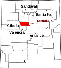 | |
| Town | ||
| Villages | ||
| CDPs | ||
| Other unincorporated communities | ||
| Indian reservations | ||
| Footnotes | ‡This populated place also has portions in an adjacent county or counties | |