Oxfordshire Ironstone Railway
Oxfordshire Ironstone Railway | |||||||||||||||||||||||||||||||||||||||||||||||||||||||||||||||||||||||||||||||||||||||||||||||||||||||||||||||||||||||||||||||||||||||||||||||||||||||||||||||||||||||||||||||||||||||||||||||||||||||||||||||||||||||||||||||||||||||||||||||||||||||||||||||||||||||||||||||||||||||||||||||||||||||||||||||||||||||||||||||||||||||||||||||||||||||||||||||||||||||||||||||||||||||||||||||||||||||||||||||||||||||||||||||||||||||||||||||||||||||||||||||||||||||||||||||||||||||||||||||||||||||||||||||||||||||||||||||||||||||||||||||||||||||||||||||||||||||||||||||||||||||||||||||||||||||||||||||||||||||||||||||||||||||||||||||||||||||||||||||||||||||||||||||||||||||||||||||||||||||||||||||||||||||||||||||||||||||||||||||||||||||||||||||||||||||||||||||||||||||||||||||||||||||||||||||||||||||||||||||||||||||||||||||||||||||||||||||||||||||||||||||||||||||||||||||||||||||||||||||||||||||||||||||||||||||||||||||||||||||||||||||||||||||||||||||||||||||||||||||||||||||||||||||||||||||||||||||||||||||
|---|---|---|---|---|---|---|---|---|---|---|---|---|---|---|---|---|---|---|---|---|---|---|---|---|---|---|---|---|---|---|---|---|---|---|---|---|---|---|---|---|---|---|---|---|---|---|---|---|---|---|---|---|---|---|---|---|---|---|---|---|---|---|---|---|---|---|---|---|---|---|---|---|---|---|---|---|---|---|---|---|---|---|---|---|---|---|---|---|---|---|---|---|---|---|---|---|---|---|---|---|---|---|---|---|---|---|---|---|---|---|---|---|---|---|---|---|---|---|---|---|---|---|---|---|---|---|---|---|---|---|---|---|---|---|---|---|---|---|---|---|---|---|---|---|---|---|---|---|---|---|---|---|---|---|---|---|---|---|---|---|---|---|---|---|---|---|---|---|---|---|---|---|---|---|---|---|---|---|---|---|---|---|---|---|---|---|---|---|---|---|---|---|---|---|---|---|---|---|---|---|---|---|---|---|---|---|---|---|---|---|---|---|---|---|---|---|---|---|---|---|---|---|---|---|---|---|---|---|---|---|---|---|---|---|---|---|---|---|---|---|---|---|---|---|---|---|---|---|---|---|---|---|---|---|---|---|---|---|---|---|---|---|---|---|---|---|---|---|---|---|---|---|---|---|---|---|---|---|---|---|---|---|---|---|---|---|---|---|---|---|---|---|---|---|---|---|---|---|---|---|---|---|---|---|---|---|---|---|---|---|---|---|---|---|---|---|---|---|---|---|---|---|---|---|---|---|---|---|---|---|---|---|---|---|---|---|---|---|---|---|---|---|---|---|---|---|---|---|---|---|---|---|---|---|---|---|---|---|---|---|---|---|---|---|---|---|---|---|---|---|---|---|---|---|---|---|---|---|---|---|---|---|---|---|---|---|---|---|---|---|---|---|---|---|---|---|---|---|---|---|---|---|---|---|---|---|---|---|---|---|---|---|---|---|---|---|---|---|---|---|---|---|---|---|---|---|---|---|---|---|---|---|---|---|---|---|---|---|---|---|---|---|---|---|---|---|---|---|---|---|---|---|---|---|---|---|---|---|---|---|---|---|---|---|---|---|---|---|---|---|---|---|---|---|---|---|---|---|---|---|---|---|---|---|---|---|---|---|---|---|---|---|---|---|---|---|---|---|---|---|---|---|---|---|---|---|---|---|---|---|---|---|---|---|---|---|---|---|---|---|---|---|---|---|---|---|---|---|---|---|---|---|---|---|---|---|---|---|---|---|---|---|---|---|---|---|---|---|---|---|---|---|---|---|---|---|---|---|---|---|---|---|---|---|---|---|---|---|---|---|---|---|---|---|---|---|---|---|---|---|---|---|---|---|---|---|---|---|---|---|---|---|---|---|---|---|---|---|---|---|---|---|---|---|---|---|---|---|---|---|---|---|---|---|---|---|---|---|---|---|---|---|---|---|---|---|---|---|---|---|---|---|---|---|---|---|---|---|---|---|---|---|---|---|---|---|---|---|---|---|---|---|---|---|---|---|---|---|---|---|---|---|---|---|---|---|---|---|---|---|---|---|---|---|---|---|---|---|---|---|---|---|---|---|---|---|---|---|---|---|---|---|---|---|---|---|---|---|---|---|---|---|---|---|---|---|---|---|---|---|---|---|---|---|---|---|---|---|---|---|---|---|---|---|---|---|---|---|---|---|---|---|---|---|---|---|---|---|---|---|---|---|---|---|---|---|---|---|---|---|---|---|---|---|---|---|---|---|---|---|---|---|---|---|---|---|---|---|---|---|---|---|---|---|---|---|---|---|---|---|---|---|---|---|---|---|---|---|---|---|---|---|---|---|---|---|---|---|---|---|---|---|---|---|---|---|---|---|---|---|---|---|---|---|---|---|---|---|---|---|---|---|---|---|---|---|---|---|---|---|---|---|---|---|---|---|---|---|---|---|---|---|---|---|---|---|---|---|---|---|---|---|---|---|---|---|---|---|---|---|---|---|---|---|---|---|---|---|---|---|---|---|---|---|---|---|---|---|---|---|---|---|---|---|---|---|---|---|---|---|---|---|---|---|---|---|---|---|---|---|---|---|---|---|---|---|---|---|---|---|---|---|---|---|---|---|---|---|---|---|---|---|---|---|---|---|---|---|---|---|---|---|---|---|---|---|---|---|---|---|---|---|---|---|---|---|---|---|---|---|---|---|---|---|---|---|---|---|---|---|---|---|---|---|---|---|---|---|---|---|---|---|---|---|---|---|---|---|---|---|---|---|---|---|---|---|---|---|---|---|---|---|---|---|---|---|---|---|---|
| |||||||||||||||||||||||||||||||||||||||||||||||||||||||||||||||||||||||||||||||||||||||||||||||||||||||||||||||||||||||||||||||||||||||||||||||||||||||||||||||||||||||||||||||||||||||||||||||||||||||||||||||||||||||||||||||||||||||||||||||||||||||||||||||||||||||||||||||||||||||||||||||||||||||||||||||||||||||||||||||||||||||||||||||||||||||||||||||||||||||||||||||||||||||||||||||||||||||||||||||||||||||||||||||||||||||||||||||||||||||||||||||||||||||||||||||||||||||||||||||||||||||||||||||||||||||||||||||||||||||||||||||||||||||||||||||||||||||||||||||||||||||||||||||||||||||||||||||||||||||||||||||||||||||||||||||||||||||||||||||||||||||||||||||||||||||||||||||||||||||||||||||||||||||||||||||||||||||||||||||||||||||||||||||||||||||||||||||||||||||||||||||||||||||||||||||||||||||||||||||||||||||||||||||||||||||||||||||||||||||||||||||||||||||||||||||||||||||||||||||||||||||||||||||||||||||||||||||||||||||||||||||||||||||||||||||||||||||||||||||||||||||||||||||||||||||||||||||||||||||
The Oxfordshire Ironstone Railway was a standard-gauge mineral railway that served an ironstone quarry near the village of Wroxton in Oxfordshire.[1][2][3]
The line's history
The OIR linked the quarry with the Great Western Railway about 6 kilometres (3.7 mi) to the east at a junction just north of Banbury.[4][2][2] The line was opened between 1917 and 1919[5] and closed in 1967;[5] the line was 'lifted', that is the line was formally closed and physically removed from the site, between 1967 and 1968. The quarry was heavily worked in the Second World War.[6] The line also served the Banbury Alcan works at one point.[7] The popular footpath from Drayton to Drayton Lodge crossed the railway at Drayton Crossing.[8]
Wroxton Central Ironstone Quarry was opened by 1919, closed and filled in 1967. Langley Ironstone Quarry was built near Balscot by 1926, and was closed and filled during 1943 when it ran out of ironstone.[9][10] Dyke Lane Bridge was built in 1940 and abandoned in 1967.[2][9][10]
The line was extended to the Balscote Quarry which was worked between 1956 and its closure in 1967.[11] Balscote Quarry, a shorter-lived working, was built by 1956, but closed and filled in 1967.[2][2][11][12] A newer quarry close by its former site is now served by road haulage only.
The mine buildings, manager's house and workers' halt are now a small set of new light industrial buildings, built circa 2006–2008.[5][4] The track works' permanent way huts (p-huts)[4] still stood at Drayton in 2007 and Horley in 2002.[4] A few old OIR fence posts/gates remain to this day along the route. Banbury's Ruscote and Hardwick estate's (Daimler Avenue, Devon Way and Longends Way)[4] are also built over a large part of its route, including most of the former Pen Hill farm grading works (Longends Way). Other built over places include the proposed minor Pin Hill maintenance depot (Pin Hill Road)[13] and major active Pen Hill maintenance depot (Beaumont Road).[4][14][15]
Train fleet
The OIR operated its own fleet of steam locomotives: 0-6-0T and 0-6-0ST locomotives built by Hunslet and 0-4-0ST's built by Hudswell Clarke.[16] They also purchased two diesel Rolls Royce Sentinel units in the 1960s.[17]
Local geology
Many heavy clay and Ironstone deposits surround Banbury and Wroxton.[3][18]
The Edge Hill Light Railway connection
The firm behind the Oxfordshire Ironstone Railway was one of the backers of the ill-fated 1920–1922 Edge Hill Light Railway.[19]
There was talk of reopening the by then overgrown, but workable line early in to World War II but, it was decided that the Oxfordshire Ironstone line was to be considered adequate to serve the area's requirements.[20]
See also
References
- ↑ "Geograph:: Fields on the site of the old Langley... (C) Oliver Dixon".
- 1 2 3 4 5 6 http://www.deddingtonhistory.uk/ironstone/ironstonepics.html
- 1 2 "Take a ride on our lost railways".
- 1 2 3 4 5 6 "Old-Maps - the online repository of historic maps - home page". www.old-maps.co.uk.
- 1 2 3 "Geograph:: Oxfordshire Ironstone Quarries... (C) David Stowell".
- ↑ "Geograph:: Course of Ironstone quarry railway (C) David Stowell".
- ↑ "Geograph:: Site of bridge over the dismantled... (C) Roger Templeman".
- ↑ "Geograph:: Site of Drayton Crossing (C) David Stowell".
- 1 2 "Geograph:: Site of Langley Ironstone Quarry (C) David Stowell".
- 1 2 "Geograph:: Dyke Lane Bridge (C) David Stowell".
- 1 2 "Geograph:: Stratford Road bridge and Balscote... (C) David Stowell".
- ↑ https://www.old-maps.co.uk/#/Map/443348/240172/12/100954
- ↑ "House Prices in Pinhill Road, Banbury, Oxfordshire, OX16". www.rightmove.co.uk.
- ↑ "property to let in Penhill Industrial Park, Beaumont Road, Banbury, Oxfordshire, OX16 1RW - £10000 pa". www.brown-co.com.
- ↑ "Actecs - Banbury, Oxfordshire, United Kingdom". Yelp.
- ↑ Waters, Laurence (1991). Oxfordshire Railways in Old Photographs, a Second Selection. Stroud: Sutton Publishing. ISBN 0-86299-852-2.
- ↑ http://www.nvr.org.uk/istg/oic.php
- ↑ https://docs.google.com/viewer?a=v&q=cache:sppuMpvgMg8J:www.oum.ox.ac.uk/learning/pdfs/oxmin.pdf+clay+pits+in+banbury&hl=en&gl=uk&pid=bl&srcid=ADGEESgn-Yi-g1qgnV32eBJ5Bi24KzjITDU7kcw_uL-KWGxPnzzgLbT8n9stdyOyB9bxEnAdJs1yyzKFGNwmj0NWApex23PAad6KTYb4lJdKEqLBNLnqifn3yk8Xc8Fp-ya8DY20dPo5&sig=AHIEtbREJLbdRHQ5aetZoqTAk3mdY2Gy0w
- ↑ "Geograph:: Edge Hill Light Railway embankment (C) David Stowell".
- ↑ http://www.hfstephens-museum.org.uk/other-railways/edge-hill.html
External links
- Photo gallery of the disused railway
- http://www.geograph.org.uk/photo/199182
- http://www.geograph.org.uk/photo/199179
- http://www.geograph.org.uk/photo/197427
- http://www.geograph.org.uk/photo/199174
- http://www.geograph.org.uk/photo/199177
- http://apollopark.uk/
- http://www.deddingtonhistory.uk/ironstone/ironstonepics.html
- http://www.geograph.org.uk/photo/199174
- http://www.geograph.org.uk/photo/199177
- http://www.steve-banks.org/prototype-and-traffic/202-banbury-yards-and-freight
- http://www.geograph.org.uk/photo/199179
- http://www.rightmove.co.uk/house-prices/OX16/Pinhill-Road.html
Books
Historic imagery of the site
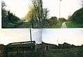
 A picture of the former Wroxton Qarry's Pin Hill farm grading works in Banbury, Oxfordshire in 2001.
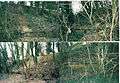
 Picture of the former ironstone quarry works at Wroxton in 2001.
 Pictures of the surviving huts at the former quarry in 2001 and the track bed in Hardwick during 2001.
 A picture of the mine manager's office in 2001.
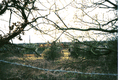 A picture of the former ironstone quarry works at Wroxton in 2001.
 Oxfordshire Ironstone Railway's OIR P-hut at Drayton, Oxfordshire in 2005. At the far right is a pile of rubble was ware a signal post used to be.
 Some shots of Wroxton's old ironstone mine in 2001.
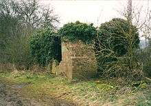
 Horley's OIR tool hut or a p-hut in 2001 outside and 2002 inside. It's overgrown and in the bushes now.
 Shots of both sides of Horley's OIR tool hut or a p-hut in 2001. It's overgrown and in the bushes now.
 A OIR track to sleeper pin in Drayton. The words stamped on it say it was made by the Great Western Railway in 1928. It was found in 2002.
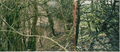 Drayton's OIR tool shed in 2004.
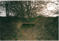 A broken old pipe in Hardwick. It is not part of any mains system I know of and looks very old and corroded, so it was probably part of the OIR's grading works.