Oxford–Crown Historic District
|
Oxford–Crown Historic District | |
 Pleasant Street at Crown Street | |
  | |
| Location | Roughly bounded by Chatham, Congress, Crown, Pleasant, Oxford Sts. and Oxford Pl., Worcester, Massachusetts |
|---|---|
| Coordinates | 42°15′54″N 71°48′30″W / 42.26500°N 71.80833°WCoordinates: 42°15′54″N 71°48′30″W / 42.26500°N 71.80833°W |
| Built | 1836 |
| Architect | Earle, Stephen C.; Multiple |
| Architectural style | Mid 19th Century Revival, Greek Revival, Renaissance |
| MPS | Worcester MRA |
| NRHP reference # |
76000954[1] (original) 80000605 (increase) |
| Significant dates | |
| Added to NRHP | May 06, 1976 |
| Boundary increase | March 05, 1980 |
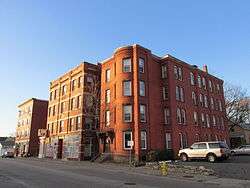
Oxford–Crown Historic District is a historic district roughly bounded by Chatham, Congress, Crown, Pleasant, Oxford Streets and Oxford Place in Worcester, Massachusetts.
The district contains Mid 19th Century Revival, Greek Revival, and Renaissance architecture. The area was added to the National Register of Historic Places in 1976, and expanded in 1980.[1]
Due to its proximity to the city's downtown and the assemblage of historically significant properties, the Crown Hill Neighborhood Association gathered to petition City Council to form a Local Historic District in 2008. In October 2010, the Crown Hill Survey Project commenced and in February 2011 the boundaries were created with the help of the neighborhood's property owners. Approval was granted by the Worcester Historical Commission two years after efforts began.[2]
See also
References
- 1 2 National Park Service (2008-04-15). "National Register Information System". National Register of Historic Places. National Park Service.
- ↑ Worcester Historical Commission. "Crown Hill Local Historic District" (PDF). Retrieved 19 February 2013.
| Topics |  | ||||||||||||||||
|---|---|---|---|---|---|---|---|---|---|---|---|---|---|---|---|---|---|
| Lists by county | |||||||||||||||||
| Lists by city |
| ||||||||||||||||
| Other lists | |||||||||||||||||
| |||||||||||||||||