Ovaro
| Ovaro | |
|---|---|
| Comune | |
| Comune di Ovaro | |
 Ovaro Location of Ovaro in Italy | |
| Coordinates: 46°29′N 12°52′E / 46.483°N 12.867°ECoordinates: 46°29′N 12°52′E / 46.483°N 12.867°E | |
| Country | Italy |
| Region | Friuli-Venezia Giulia |
| Province | Province of Udine (UD) |
| Frazioni | Agrons, Cella, Chialina, Clavais, Cludinico, Entrampo, Lenzone, Liariis, Luincis, Luint, Mione, Muina, Ovasta |
| Area | |
| • Total | 57.8 km2 (22.3 sq mi) |
| Elevation | 525 m (1,722 ft) |
| Population (Dec. 2004) | |
| • Total | 2,166 |
| • Density | 37/km2 (97/sq mi) |
| Demonym(s) | Ovaresi |
| Time zone | UTC+1 (CET) |
| • Summer (DST) | UTC+2 (CEST) |
| Postal code | 33025 |
| Dialing code | 0433 |
| Website | Official website |
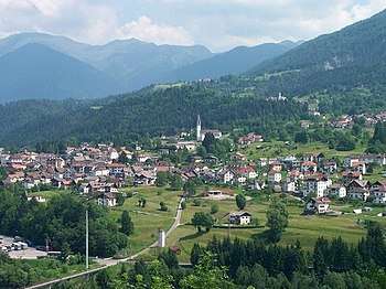
the town in spring
Ovaro (Friulian: Davâr) is a comune (municipality) in the Province of Udine in the Italian region Friuli-Venezia Giulia, located about 120 kilometres (75 mi) northwest of Trieste and about 50 kilometres (31 mi) northwest of Udine. As of 31 December 2004, it had a population of 2,166 and an area of 57.8 square kilometres (22.3 sq mi).[1]
The municipality of Ovaro contains the frazioni (subdivisions, mainly villages and hamlets) Agrons, Cella, Chialina, Clavais, Cludinico, Entrampo, Lenzone, Liariis, Luincis, Luint, Mione, Muina, and Ovasta.
Ovaro borders the following municipalities: Ampezzo, Comeglians, Lauco, Prato Carnico, Ravascletto, Raveo, Sauris, Socchieve, Sutrio.
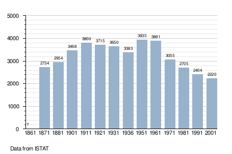
Demographic evolution
References
External links

This article is issued from
Wikipedia.
The text is licensed under Creative Commons - Attribution - Sharealike.
Additional terms may apply for the media files.