Ouachita Avenue Historic District
|
Ouachita Avenue Historic District | |
 | |
  | |
| Location | Bounded by Ouachita Ave., Orange St., Central Ave. & Olive St., Hot Springs, Arkansas |
|---|---|
| Coordinates | 34°30′23″N 93°3′21″W / 34.50639°N 93.05583°WCoordinates: 34°30′23″N 93°3′21″W / 34.50639°N 93.05583°W |
| Area | 9 acres (3.6 ha) |
| Built | 1905 |
| NRHP reference # | 11000690[1] |
| Added to NRHP | September 23, 2011 |
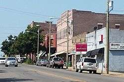
The Ouachita Avenue Historic District encompasses a commercial and residential district south of Bathhouse Row in downtown Hot Springs, Arkansas. It includes an area of three square blocks bounded by Ouachita Avenue, Orange and Olive Streets, and Central Avenue. This area was completely devastated by a fire in 1905, and damaged by another in 1913, and it is after these events that its most significant buildings were built. It contains a variety of commercial buildings (mostly on Ouachita Avenue, multiunit and single-family housing, in a dense pedestrian-friendly urban setting.[2]
The district was listed on the National Register of Historic Places in 2011.[1]
See also
References
- 1 2 National Park Service (2010-07-09). "National Register Information System". National Register of Historic Places. National Park Service.
- ↑ "NRHP nomination for Ouachita Avenue Historic District" (PDF). Arkansas Preservation. Retrieved 2015-10-22.
| Topics | |
|---|---|
| Lists by states |
|
| Lists by insular areas | |
| Lists by associated states | |
| Other areas | |
| |
This article is issued from
Wikipedia.
The text is licensed under Creative Commons - Attribution - Sharealike.
Additional terms may apply for the media files.