Otočec Castle
.jpg)

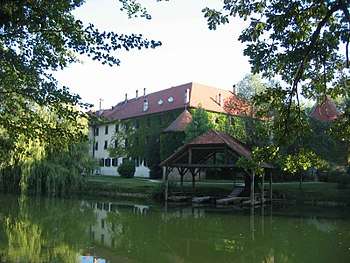
Otočec Castle (aka Grad Otočec) is a castle hotel on a small island in the middle of the Krka River in Otočec, Slovenia, which is also near the municipality of Novo Mesto, which is part of the traditional region of Lower Carniola and is now included in the Southeast Slovenia Statistical Region. It is the only water castle in Slovenia. The word Otočec itself in Slovenian, means "small island".
Overview
The castle was first mentioned in documents in the 13th century,[1] although the walls are said to date to the more precise date of 1252.[2] Of the 30 small islets in the Krka River in this area, the Otočec Castle is on the largest island, which was formed by cutting a southern channel around the castle, in order to form a moat around it.
The island is linked to both banks of the river by two [2] wooden bridges (one northern bridge & one southern bridge), so that you can drive from either the north side or the south side, straight through the islet, to the opposite side of the river. There is parking at the entrance of the northern bridge and on the islet itself, but there is no parking at the entrance to the southern bridge.
The Otočec Castle has now been converted into a small luxury hotel, and it also has a world–class restaurant on–site. Bradt Travel Guides[3] calls it "one of the most famous hotels in Slovenia."[4] It is also a member of Relais & Châteaux, which is a global fellowship of individually owned and operated luxury hotels and restaurants.
There is also a boat house (located on the southern channel @ the back of the castle). There is also a golf course, a castle park, and an adventure park which includes a ropes course [for children and adventure climbers], located on the island on which Otočec Castle is situated.
History
It was once owned by Ivan Lenković, the leader of the Uskoks, and the chief commander of the Croatia-Slavonia March, which was at one time, a province straddling the southern borderland of the Habsburg Monarchy, and later the Austrian Empire & Austro-Hungarian Empire. The writer Ivan Tavčar set two of his novels at the castle, Otok and Struga & Janez Sonce.[2] The castle was home to the de Werde noblemen in the 13th century, who were also known as the Knights of Otočec, and the other tenants were the Villanders nobles of Tyrol as well.
Before World War II the castle was owned by the House of Marghieri de Commadona. At the beginning of World War II the castle was seized by the Italians and used as a fortress. In 1942, it was burnt by the Partisans and only ruins remained of the two bridges. The castle’s restoration began in 1952 with the restoration of the roof and lasted for 6 years, with the help of various international work brigades. In 1959, the first restaurant was opened in the restored castle. Over the next few decades the castle changed its appearance until it was restored to its original Gothic and Renaissance splendor.
Highways
The Otočec Castle can be reached by taking the A2 Motorway from Novo Mesto to Otočec, which is part of Pan-European Corridor X, which passes through Salzburg — Ljubljana — Zagreb — Beograd — Niš — Skopje — Veles — Thessaloniki, and is 2,300 kilometers (1,429 miles) long. The A2 Motorway (Slovene: avtocesta A2, Ilirika) is a motorway in Slovenia, around 180 km. (111 miles) long, connecting the Karavanke (or Karawanks) Tunnel (at the Austrian border) via the capital city Ljubljana to Obrežje (at the Croatian border, near Zagreb). It connects several major Slovene cities, including Kranj, Ljubljana, and Novo Mesto.
See also
- Map of the A2 Motorway in Slovenia.
- Map of the Pan European Corridor X in Slovenia.
- Otočec, Slovenia, a settlement on the left bank of the Krka River in the Municipality of Novo Mesto near the Otočec Castle.
References
- ↑ Večerić, Danica (31 August 2006). Slovenia. The Oliver Press, Inc. p. 7. ISBN 978-1-881508-74-8. Retrieved 30 June 2012.
- 1 2 "Otočec Castle". Slovenia.info. Retrieved 30 June 2012.
- ↑ Robert, Hennry (May 9, 2011). "Travel Guide".
- ↑ McKelvie, Robin; McKelvie, Jenny (13 August 2008). Slovenia: The Bradt Travel Guide. Bradt Travel Guides. p. 179. ISBN 978-1-84162-211-8. Retrieved 30 June 2012.
External links
- Otočec Castle [Official Site]
- Otočec & Otočec Castle on Geopedia
- Otočec Castle Info @ Slovenia Heritage.net

