Otakou
| Otakou Ōtākou (Māori) | |
|---|---|
 Ōtākou Marae | |
| Country | New Zealand |
| Region | Otago |
| Territorial authority | Dunedin City Council |
| Time zone | UTC+12 (NZST) |
| • Summer (DST) | UTC+13 (NZDT) |
| Local iwi | Ngāi Tahu |
Otakou (Māori: Ōtākou) is a settlement within the boundaries of the city of Dunedin, New Zealand. It is located 25 kilometres from the city centre at the eastern end of Otago Peninsula, close to the entrance of Otago Harbour.[1][2][3]
Overview
Though a small fishing village, Otakou is important in the history of Otago for several reasons. The name 'Ōtākou' is thought to come from Māori words meaning either "single village" or "place of red earth". Prior to the standardisation of Māori spelling in the 1840s, the name was written as 'Otago', reflecting its pronunciation in a local southern Māori dialect. This prestandardised form was adopted by European settlers as the name for the surrounding area, the Otago region, and it is commonly mistaken as a European corruption of 'Otakou'.[4]
The name originally referred to the channel off Wellers Rock but was transferred to the lower harbour as a whole, the port, the nearby Māori settlements and the Weller brothers' whaling establishment, one of the region's oldest European settlements, which had been founded in 1831. The old Māori names for the Māori settlements were Te Ruatitiko, Tahakopa, Omate and Ohinetu.
Otakou was probably also the "city of Otago" burnt by Captain Kelly in December 1817 during the Sophia incident.[5][6]
Prior to the arrival of European settlers, the place was a prominent Māori settlement, and it is still the site of Otago's most important marae. By the early 19th century, the three Māori iwi of Ngāi Tahu, Kāti Māmoe and Waitaha had blended into a single tribal entity. The Treaty of Waitangi was signed nearby in 1840 on the H.M.S Herald by two important chiefs, who were descended from all three tribes. Otakou remains an important centre of Ngāi Tahu life.
Otakou is located close to Taiaroa Head, the site of an albatross colony and other wildlife such as seals and penguins. Local Māori still call Taiaroa Head by its original name, Pukekura, which was also the name of the pā (fortification) established there around 1750 and still occupied by Māori in the 1840s, before the land was taken by the Government under the Public Works Act for building the lighthouse and the fortifications used during the Russian Scare of the 1880s.[1][2][3]
Culture
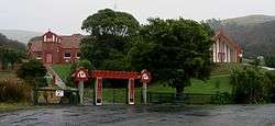
Ōtākou Marae marae is located in Otakou. It is a marae (meeting ground) of Ngāi Tahu and the branch of Te Rūnanga o Ōtākou, and includes the Tamatea wharenui (meeting house).[7][8]
References
- 1 2 Dann, C. & Peat, N. (1989). Dunedin, North and South Otago. Wellington, NZ: GP Books. ISBN 0-477-01438-0.
- 1 2 Entwisle, Peter. (1998) Behold the Moon, the European Occupation of the Dunedin District 1770-1848'. Dunedin, NZ: Port Daniel Press. ISBN 0-473-05591-0
- 1 2 Goodall, M. & Griffiths, G. (1980). Māori Dunedin. Dunedin, NZ: Otago Heritage Books.
- ↑ McKinnon, Malcolm (2012). Otago region - The Otago settlement.
- ↑ McNab, Robert (1906). "The Sophia Massacre, 1817". Murihiku: A History of the South Island of New Zealand and the Islands Adjacent and Lying to the South, from 1642 to 1835. pp. 225–230.
- ↑ Hamilton, A (1895). "On an Account of a Massacre at the Entrance of Dunedin Harbour in the Year - 1817". Transactions and Proceedings of the Royal Society of New Zealand. 28: 141–147.
- ↑ "Te Kāhui Māngai directory". tkm.govt.nz. Te Puni Kōkiri.
- ↑ "Māori Maps". maorimaps.com. Te Potiki National Trust.